Shigatse is in south-central Tibet, an autonomous region of China, west of Lhasa. Its city center lies in Sangzhuzi District, beside the Nyang Chu and near the Yarlung Tsangpo valley. The direct high-grade road from Lhasa is about 245 km. But the name Shigatse also covers a region stretching to Everest and the Nepal border. Which Shigatse does your itinerary mean?
Quick summary
- Shigatse city is west of Lhasa in south-central Tibet, China. Look for Sangzhuzi when you need the urban center.
- The direct Lhasa–Shigatse high-grade road is about 245 km. A journey through Yamdrok and Gyantse is a different, longer route.
- Everest and the Nepal border are in the wider Shigatse region. Neither is close to the city center.
- From Lhasa, road and rail are the two clear connections. Check the train you plan to take; Shigatse Peace Airport is another, separate arrival point.
The Shigatse You Reach from Lhasa
If your first Tibet route reads “Lhasa to Shigatse,” it usually means a night in the city. That city is Sangzhuzi, the urban center west of Lhasa. You have reached a proper stop, with a railway station, streets and places to stay. You have not reached the foot of Everest or the Nepal border simply because both lie within a region also named Shigatse.
The direct Lhasa–Shigatse high-grade road corridor is about 245 km long. Xinhua reported on 30 June 2024 that its full opening reduced the drive between the two cities to around three hours. That is a reported intercity journey time, not a guaranteed hotel-to-hotel transfer. Allow additional time for pickup, breaks, traffic and the final drive to your address.
There is another reason you may see a larger distance. Many Tibet journeys leave Lhasa by way of Yamdrok Lake and Gyantse before arriving in Shigatse. It is a worthwhile sightseeing direction if those places are on your plan, but it is not the 245 km direct road with a few extra stops added. The road itself takes a different shape.
If all you need is to move between the cities, compare the direct drive with the train. If Yamdrok and Gyantse are part of the day, give them the time they deserve and read that route on its own map. This one choice clears up many conflicting “Shigatse distance from Lhasa” answers before you leave Lhasa.
Find the City on a World Map, Then Follow the Rivers
At world scale, Shigatse is in Asia. At country scale, it is in southwest China, within the Tibet Autonomous Region. On a Tibet map, look west of Lhasa toward the broad valleys of south-central Tibet. The urban center is in Sangzhuzi District on the Nyang Chu; that river joins the Yarlung Tsangpo a little north of the city.
The river detail is more than decoration. It helps you recognize the city on a closer map, where a large “Shigatse” label may otherwise spread across a wide area. It also explains why the Lhasa approach follows valley country while the later roads toward Everest climb into a very different landscape.
If you search “Shigatse on China map,” the result may show only a small city dot. Search “Shigatse on Tibet map,” and some maps shade the entire prefecture-level city. The dot and the shaded area are both Shigatse, but they answer different questions. For a hotel, station or distance from Lhasa, start with the Sangzhuzi dot.
Shigatse is also written Xigatse or Xigazê, while Mandarin-based maps may use Rikaze (日喀则). These names can appear on the same travel documents without indicating three different cities. Sangzhuzi, or Samdrubtse in another spelling, is the central district; it is the extra clue that tells you a booking is for the urban stop.
Key Map Facts for a Shigatse Location Map
| Question | Map answer | What it means for a traveler |
|---|---|---|
| Where is Shigatse? | In the Tibet Autonomous Region of China, west of Lhasa. | On a world map, zoom through Asia and southwest China to Tibet. |
| Where is the city center? | In Sangzhuzi District beside the Nyang Chu, near the Yarlung Tsangpo valley. | Use this point for a city overnight or pickup. |
| How far from Lhasa? | About 245 km on the direct high-grade intercity road. | A hotel-to-hotel drive or Gyantse route will differ. |
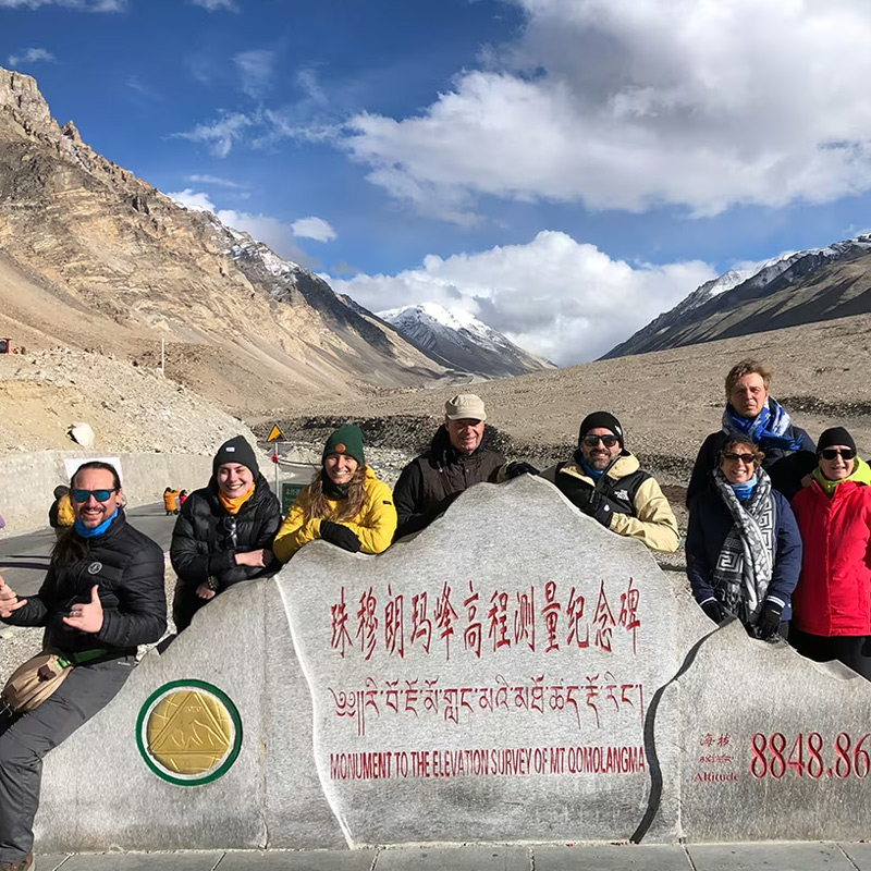
| Where is Everest? | Southwest of Shigatse city, in the wider Shigatse region. | It takes another road stage beyond the city. |
| Last checked | 21 October 2026 (Asia/Shanghai): location and published road-distance references. | See the transport-context note below; timetables, road access and border operations need date-specific confirmation. |
Why Everest Appears on a Shigatse Map
This is the part of the map that surprises people. Shigatse is not only a city. Administratively, it is a large prefecture-level area extending far southwest from Sangzhuzi. Tingri County, where travelers approach Everest from the Tibet side, lies within that area. So “Everest is in Shigatse” is true in the regional sense.
It says very little about the distance from your city hotel.
The road from Sangzhuzi heads southwest through the Lhatse and Tingri corridor before turning toward the Everest visitor area. Shigatse city, a Tingri-area stop and the Everest viewing area are different endpoints. When a distance appears online, check which of those it uses. Otherwise a number that is correct for Tingri can make the final approach disappear from your plan.
This is also why Shigatse often feels like a sensible pause on a longer journey. You can arrive from Lhasa and take a proper night in the city before continuing southwest. It does not follow that every Everest trip must use the same overnight pattern; the route and the next sleeping place still need to be planned. The Lhasa to Everest Base Camp Map handles that full journey.
And What About the Nepal Border?
The border is another place where the regional name can fool you. The southern edge of the wider Shigatse area meets Nepal, yet Sangzhuzi is far inland. On a small map, both the city and the border may fit within one colored outline. On the road, they are separate travel stages.
Even “the Nepal border” needs a second name. Gyirong, Nyalam and other border-area labels point to different valleys and approaches. Gyirong County, Gyirong Town, the crossing facility and the Nepal-side connection are not a single pin. If an itinerary simply says “Shigatse to Nepal,” it has left out the point that determines the actual road journey.
Everest and a Nepal crossing can appear on the same broad southwesterly travel plan, but they are not interchangeable destinations. A traveler heading for an Everest viewpoint needs a different end point from a traveler heading for a named border crossing. It is better to decide which one matters before using a road distance to judge the day.
There is also a practical limit to what a location map can promise. Roads and crossings may be affected by temporary controls, weather or changes in border operation. The line on the map stays where it is; access may not. Check the named crossing and the route near your travel date, especially before making a one-way international plan.
How to Get to Shigatse
For many visitors, the straightforward approach is to arrive in Lhasa first, then continue west. Road travel lets you go directly to your Shigatse address or take the separate Yamdrok–Gyantse sightseeing route. The Lhasa–Shigatse railway gives you another city-to-city choice. It reaches Shigatse Railway Station, after which you still need the short transfer to your hotel or meeting point.
If you are coming from Beijing, Shanghai, Chengdu or another major Chinese city, the first useful question is where you enter Tibet. A long-distance flight or train may bring you to Lhasa; your Shigatse leg then follows by road or rail. Do not read a China-wide map as though every gateway has a single direct train or flight to Shigatse.
Shigatse Peace Airport serves the region but sits outside the Sangzhuzi urban center in Jiangdang Township. It may be a useful arrival point when a suitable flight operates, although its name alone does not tell you the current schedule or the onward transfer. Check both before choosing it over the Lhasa approach.
Coming from Kathmandu is a different question again. The route depends on a specific China–Nepal crossing and the approved onward journey across the Shigatse region. It should not be reduced to the straight line between Kathmandu and the Shigatse city dot. The Kathmandu to Lhasa and Tibet Nepal maps take the border and multi-stage route further.
Last checked for transport context: 21 October 2026 (Asia/Shanghai). The direct road corridor, Lhasa–Shigatse rail connection and Peace Airport location were checked against official sources. This page does not assert that a particular flight or border crossing is operating on a future date. Check train times, flights, road notices, access and travel documents for the day you intend to move.
Conclusion
If you are staying in the city, Sangzhuzi is the pin you need. If Everest is next, put Tingri and your actual visitor destination on the map as well. If Nepal is next, name the crossing before treating “the border” as a destination. Those small choices reveal whether you have a simple intercity transfer or another full travel stage ahead.
Shigatse is easy to find on a map once you know where to zoom. The harder and more useful question is which place behind the name belongs on tomorrow’s road.
Share your dates and entry city with CHIBET to discuss a suitable route. Before booking, confirm the included stops and arrangements with the licensed Tibet operating agency.
Frequently Asked Questions
FAQ: Shigatse Location and Travel Questions
Is Shigatse the same as Xigatse or Rikaze?
Yes. They are different English or romanized forms of the name 日喀则. Sangzhuzi is the central district of Shigatse city, not another distant destination.
Is Shigatse in China or Nepal?
Shigatse is in the Tibet Autonomous Region of China. The wider Shigatse region reaches the China–Nepal border, but its urban center is inland.
Can you see Mount Everest from Shigatse city?
No. The city is not an Everest viewpoint. To approach the Tibet-side viewing area, travel southwest through the wider Shigatse region toward Tingri and then follow the separate Everest route.
How far is Shigatse from Lhasa by road?
The direct high-grade road between the cities is about 245 km. A route through Yamdrok and Gyantse is longer, and a map app’s hotel-to-hotel figure will depend on the addresses you enter.