A Tibet airport map answers a practical question: where can you actually land, and which airport fits your route? Eight civil passenger airports now serve the plateau, but they serve very different travel regions and routes. For first-time travelers, the airports most relevant to route planning are Lhasa Gonggar, Nyingchi Mainling and Shigatse Peace, while the others serve narrower regional purposes. This page maps all eight, then works through the choice that actually shapes your trip. It sits inside our wider Tibet map hub, which links every map page on the site.
Quick Tibet Airport Map Facts
Sources: Airport, elevation and service details draw on the Civil Aviation Administration of China Tibet branch 2026 summer–autumn season plan (published 25 March 2026; running 29 March to 24 October 2026, 210 days) and on Tibet Airlines’ announcement of the Lhasa–Dingri route effective 5 September 2026. Route networks, frequencies and seasonal schedules change each season; treat every list as a planning frame and confirm current schedules with your operator or the airline. Checked October 2026.
Tibet Airports Map: Where Can You Fly?
The first thing a Tibet airport map shows is how spread out the network is. The eight airports ring the plateau rather than cluster around the capital: Lhasa Gonggar serves the Lhasa–Shannan gateway area in the south, Nyingchi Mainling serves the forested east, Shigatse has two airports on the Everest side, Ngari has two in the far west, while Shannan Longzi and Qamdo Bamda serve more localized regional routes. Distances between them are road distances of hundreds of kilometers, so the airport you choose is really a choice about which corner of Tibet you land in.
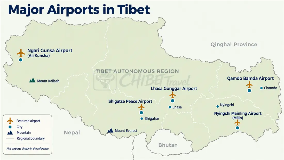
This section only answers where the airports are. What each one is worth for planning comes next, because a mark on the map and a useful gateway are not the same thing.
The Main Airport Gateways to Tibet
Eight airports on a map does not mean eight equal choices. For trip planning they split into two tiers.
Main Travel Gateways
Lhasa Gonggar is the conventional starting point for first-time visitors, with the widest range of domestic connections and the classic central-Tibet routes at its doorstep. Nyingchi Mainling is the natural entry for eastern routes toward Lulang, Bomi and Basum Tso, and it is one of the two airports the regional aviation authorities expect to see the strongest flight growth in the current season plan. Shigatse Peace is the main airport for Shigatse city and can shorten the road approach toward western Tibet and Everest. In far-western Tibet, Gunsa airport serves Shiquanhe and provides access to western Ngari, including routes toward Guge, while Purang airport sits on the Kailash side — the other airport flagged for significant growth.
Limited Regional Airports
Shigatse Dingri near the Everest area began scheduled passenger service on September 5, 2026, with Tibet Airlines flying the Lhasa route three days a week (Tuesday, Thursday and Saturday). Shannan Longzi and Qamdo Bamda connect their own regions but see thin service. These three are worth knowing about; they are not, for most travelers, the decision.
Keeping the tiers apart matters: writing about all eight as if they were interchangeable gateways would mislead someone planning a first trip, when in practice Lhasa, Nyingchi and Shigatse are the airports that matter most for mainstream Tibet itineraries.
Tibet Airport Map: Airport, Elevation and Main Travel Area
This is the planning table. Elevations follow the figures used across our Tibet map pages, so the numbers here match the rest of the site.
| Airport | IATA | Elevation | Main area served | Typical use |
|---|---|---|---|---|
| Lhasa Gonggar | LXA | 3,570 m | Lhasa / Shannan | First-time Tibet trips |
| Nyingchi Mainling | LZY | 2,949 m | Nyingchi | Eastern Tibet routes |
| Shigatse Peace | RKZ | 3,801 m | Shigatse | Shigatse / western routes |
| Shigatse Dingri | DDR | 4,316 m | Dingri / Everest area | Everest access |
| Ngari Gunsa | NGQ | 4,274 m | Ngari / Shiquanhe | Western Ngari, Guge |
| Ngari Purang | APJ | 4,255 m | Purang / Kailash side | Kailash / Manasarovar |
| Shannan Longzi | LGZ | 3,950 m | Longzi | Limited regional access |
| Qamdo Bamda | BPX | 4,333 m | Chamdo | Eastern plateau routes |
One reading rule for this table: elevation is a planning fact, not a verdict. It tells you the elevation of your arrival point — one data point for planning the first day — but does not by itself decide which airport is “easier” to handle. That question gets its own section further down.
Which Airport Should You Fly Into?
Match the airport to the trip, not the reverse.
Lhasa Gonggar: The First-Trip Choice
If this is your first trip to Tibet, Lhasa Gonggar is the conventional choice. Many classic itineraries — Potala Palace, Jokhang Temple, the Barkhor, then the southern loop toward Gyantse, Shigatse and Everest — start in Lhasa, and the city has the plateau’s most complete transport and service network; our Lhasa map breaks the city itself down by district.
Nyingchi Mainling: Entry for Eastern Tibet
Mainling puts you directly into the forested low valleys: Lulang, Bomi and Basum Tso are all reached from the Nyingchi side, without backtracking through Lhasa.
Shigatse Peace and Dingri: Everest Access
If Everest is the focus, there are three main airport options: fly to Lhasa and drive the full southern route; fly to Shigatse Peace and reduce the road time; or fly to Shigatse Dingri for the shortest airport-to-Everest road approach. Lhasa offers the widest range of flight options, while Dingri currently has a much thinner schedule, so the choice usually balances flight availability against road time — our Lhasa to Everest Base Camp map sets the road legs out day by day.
Ngari Purang and Ngari Gunsa: Kailash Access
If Mount Kailash is the main goal, compare Ngari Purang with Ngari Gunsa. Purang is on the Kailash and Manasarovar side, while Gunsa serves Shiquanhe with Guge farther to the northwest. Both see thin schedules, and many Kailash itineraries still build through Lhasa or Shigatse by road, using the flight where it fits.
Lhasa vs Nyingchi: Two Different Ways to Enter Tibet
The most common version of this question: should a first-time visitor land in Lhasa or Nyingchi? There is no universal answer: the two airports serve different routes.
| Fly to Lhasa | Fly to Nyingchi | |
|---|---|---|
| Main route | Central Tibet | Eastern Tibet |
| Typical first stop | Lhasa | Nyingchi |
| Airport elevation | 3,570 m | 2,949 m |
| Classic highlights | Potala, Jokhang, Yamdrok, Everest | Basum Tso, Lulang, Bomi |
| Best fit | First Tibet trip | Eastern Tibet route |
The route logic is simple: if your trip is built around Lhasa, Everest or central Tibet, flying to Lhasa keeps the plan linear. If eastern Tibet is the main purpose, flying to Nyingchi avoids a long detour through the capital. Travelers who land in Nyingchi and want the classic sights afterwards usually drive the Nyingchi–Lhasa link and continue from there.

Which Chinese Cities Have the Most Useful Flights to Tibet?
For many international travelers the pattern is the same: arrive in a mainland Chinese city, then connect to Tibet. The cities below cover the main options.
| Gateway city | Common Tibet destination | Why travelers use it |
|---|---|---|
| Chengdu | Lhasa, Nyingchi and other Tibet airports | One of the strongest mainland gateways, with frequent flights to multiple Tibet airports |
| Xining | Lhasa | Combined flight-and-train entry via the Qinghai–Tibet railway |
| Beijing | Lhasa | Major international arrival city with direct Lhasa service |
| Xi’an | Lhasa | Useful mid-China connection point |
| Chongqing | Lhasa, Nyingchi | Strong southwest-China connection |
Chengdu deserves the extra weight here. It functions as all three at once: an international arrival city, a major Tibet connection point, and a common starting point for combined China-and-Tibet itineraries. Xining plays a different role — many travelers fly there and continue to Lhasa by train along the Qinghai–Tibet railway, covered in detail in the Tibet train map.

Flights to Tibet: Domestic and International Routes
Two layers, kept apart because they work differently.
Domestic Connections
Chengdu, Xining, Beijing, Xi’an and Chongqing all run scheduled services into Lhasa, with Chengdu also serving Nyingchi and other Tibet airports. Routes and frequencies shift with the season and the operating airline, so treat any list — including the tables on this page — as a planning frame rather than a timetable.
International Access
International air access has widened but stays modest. The 2026 summer–autumn season plan lists four international and regional destinations from Lhasa Gonggar — Kathmandu, Pokhara, Singapore and Hong Kong — flown by Himalaya Airlines, West Air and Tibet Airlines, and describes those routes as being maintained through the season. That is the plan; what you can actually book is a separate question. At our October 2026 check, Kathmandu was the nonstop service we could confirm, operating Monday through Saturday, while the Pokhara, Singapore and Hong Kong itineraries we could see involved intermediate stops. Many international travelers still reach Tibet through a mainland Chinese gateway, and those crossing overland from Nepal use the Gyirong corridor — currently suspended since the August 26, 2026 mudslide disaster on the Nepalese side, with no reopening date announced. Check both with your operator when the trip is near.
How Long Does It Take to Fly to Tibet?
Typical airborne times for several commonly used routes (last checked: October 2026; schedules and aircraft change by season):
| Route | Typical flight time | Planning note |
|---|---|---|
| Chengdu → Lhasa | about 2–2.5 hours | The workhorse western gateway |
| Xining → Lhasa | about 2 hours | Direct Tibet gateway, train alternative available |
| Xi’an → Lhasa | about 3 hours | Central China connection |
| Beijing → Lhasa | 4.5–5 hours | Long domestic flight |
| Kathmandu → Lhasa | about an hour and a half | Himalaya-crossing international route, seasonal |
Add the ground leg to each figure: Lhasa Gonggar sits roughly an hour’s drive from the city, and the Kathmandu flight lands at Gonggar too, not in Lhasa itself. Window-seat views of the Himalaya on the Kathmandu approach are common, though which peaks appear depends on the day’s track.
Airport to Route: What Happens After You Land?
An airport is an entry point, not a destination. What determines the trip is the chain after touchdown: airport, road transfer, overnight base, onward route. The table below shows where each airport actually plugs in.
| Airport | Main onward route |
|---|---|
| Lhasa Gonggar | Lhasa city → Yamdrok Lake → Shigatse → Everest |
| Nyingchi Mainling | Nyingchi → Lulang → Bomi / Basum Tso |
| Shigatse Peace | Shigatse city → Gyantse → Everest / western Tibet |
| Shigatse Dingri | Dingri → Everest area |
| Ngari Gunsa | Shiquanhe → Guge / western Ngari |
| Ngari Purang | Purang → Manasarovar → Kailash |
| Shannan Longzi | Longzi county / southeastern Tibet |
| Qamdo Bamda | Chamdo → eastern plateau routes |

For the roads themselves, the Tibet travel route map and the Tibet road map take over where this page ends. On the paperwork side, one brand note: CHIBET Travel advises on route design, gateway selection and flight planning, while permit applications, airport pickups and guiding are handled by licensed operating partners in Tibet — we coordinate, they execute.
Does Airport Altitude Matter When Planning a Tibet Trip?
It matters, but airport elevation is only one part of the altitude profile. The airports span roughly 1,400 m of elevation, from Nyingchi Mainling at 2,949 m to Qamdo Bamda at 4,333 m, and that difference shapes the conditions of your first day on the ground.
But the airport number is only the first data point in a route profile that unfolds over days. Your overnight stops, driving days and the highest pass you cross matter more than the runway elevation alone — a route that starts in lower-elevation Nyingchi but climbs quickly toward high passes has a very different altitude profile from one that starts in Lhasa and spends the first two days there. The sensible approach is to plan the altitude profile of the whole route, which the Tibet altitude map lays out, rather than optimize for the airport figure.
Tibet Airport Map: Quick Comparison
| If you want to… | Look at… |
|---|---|
| Visit Lhasa for the first time | Lhasa Gonggar (LXA) |
| Travel eastern Tibet | Nyingchi Mainling (LZY) |
| Base yourself in Shigatse | Shigatse Peace (RKZ) |
| Reach the Everest area | Lhasa, Shigatse Peace or Dingri, by route shape |
| Visit Mount Kailash | Ngari Purang (APJ) or Ngari Gunsa (NGQ) |
| Explore Guge and western Ngari | Ngari Gunsa (NGQ) |
| Visit Chamdo | Qamdo Bamda (BPX) |
| Travel southeastern Tibet | Shannan Longzi (LGZ) |
Frequently Asked Questions
Tibet Airport Map: Common Questions
What is the main airport in Tibet?
Lhasa Gonggar (LXA) is the main gateway: it has the largest scheduled network, serves as the main air gateway for central Tibet, and sits about an hour’s drive from Lhasa city. Main gateway does not mean only airport — seven others serve different regions — but for a first trip it is the conventional entry point.
How many airports are there in Tibet?
Eight civil passenger airports: Lhasa Gonggar, Nyingchi Mainling, Shigatse Peace, Shigatse Dingri, Ngari Gunsa, Ngari Purang, Shannan Longzi and Qamdo Bamda, per the Tibet regional aviation authorities’ 2026 summer–autumn season plan (last checked: October 2026). Schedules at the newer airports remain thin.
Which airport should I fly into for a first Tibet trip?
Lhasa Gonggar is the usual starting point because the classic central-Tibet itinerary — Lhasa, Yamdrok, Gyantse, Shigatse, Everest — begins there. Nyingchi Mainling is a reasonable alternative when eastern Tibet is the priority. The decision follows the route, not a ranking of airports.
Is Nyingchi a good alternative to Lhasa for entering Tibet?
It depends on the route. Nyingchi Mainling sits lower, at 2,949 m, and puts you directly into the eastern valleys of Lulang, Bomi and Basum Tso. Its network is growing — the 2026 season plan flags Nyingchi for significant flight growth — but it remains smaller than Lhasa’s, and reaching the classic Lhasa–Everest sights still requires the drive west. For a first trip centered on central Tibet, Lhasa is the simpler choice.
Can I fly directly from Kathmandu to Lhasa?
Yes, though options differ. Beyond the Kathmandu route, Lhasa’s 2026 season plan also covers Pokhara, Singapore and Hong Kong — but when we checked booking channels in October 2026, Kathmandu was the nonstop service we could confirm, operating Monday through Saturday, while the other services made intermediate stops. Travelers from Europe, North America and most other overseas markets normally connect through a mainland Chinese city or one of these gateways. The overland Gyirong crossing is currently suspended with no reopening date announced.
Does Nyingchi airport change how I should plan my itinerary?
Yes. Nyingchi Mainling is useful when eastern Tibet is the main focus, and its flight options are increasing rather than shrinking. Even so, if your itinerary continues to Lhasa, leave enough time for the overland journey instead of a tight same-day connection, and note that valley fog and wind can hold flights — a buffer day keeps the rest of the route flexible.
Which airport is closest to Mount Kailash?
Ngari Purang (APJ), at 4,255 m, is the closer airport for Kailash and Lake Manasarovar; Ngari Gunsa (NGQ) serves Shiquanhe and Guge to the north. Both see limited schedules, and many Kailash itineraries reach the mountain overland through Shigatse and Saga instead, using the flights where the schedule allows.