The Himalayas run along Tibet’s southern edge, with Shigatse and Tingri providing the main approach to the Everest region. A Tibet Himalayas map helps you choose between broad roadside panoramas, the north-side Everest view near Rongbuk, and routes farther west toward Shishapangma. Those are different viewing experiences, even when the same mountains appear on the horizon.
If Everest is your main reason for coming, the Rongbuk approach gives your journey a clear focus. If you hope to understand the whole wall of peaks, a mountain-pass panorama can be just as important. Getting closer to one summit often narrows the view of its neighbours.
If you first want to place Everest in relation to China and Nepal, the Everest location map explains its border setting. The viewing choices here follow the mountain range and the roads that face it.
Tibet Himalayas map: follow the southern edge
The Himalayan arc extends broadly from west to east along the southern Tibetan Plateau, facing Nepal, Bhutan and India in different sections. The mountain belt and international boundaries are separate features; neither is an exact outline of the other.
The range also extends well beyond the Everest area. Toward southeastern Tibet, the Yarlung Tsangpo bends around the Namcha Barwa region near the eastern end of the Himalayas, as shown in NASA’s account of the river gorge. That steep, greener country looks very different from the open northern approaches around Tingri.
For a first journey focused on the best-known high peaks, the Shigatse-to-Tingri corridor is a practical starting point. The wider Tibet map places it southwest of Lhasa, rather than immediately outside the capital.
Quick Facts
Himalayan peaks in Tibet: three summits to place first
Everest and Cho Oyu sit on the China–Nepal boundary. Shishapangma lies farther west, entirely within Tibet. The three belong to the Himalayas, but their road approaches do not follow one continuous line beneath the summits.
| Peak | Elevation | Range | Position | Common viewing direction |
|---|---|---|---|---|
| Everest / Qomolangma | 8,848.86 m | Himalaya | China–Nepal boundary, south of Tingri | South toward the north face from the Rongbuk approach |
| Cho Oyu | 8,201 m* | Himalaya | West of Everest on the China–Nepal boundary | South from suitable Tingri-area viewpoints; west of Everest in a broad panorama |
| Shishapangma | 8,027 m* | Himalaya | Nyalam County, west of Cho Oyu | South from suitable Peiku Tso-area road and lakeside viewpoints |
Everest’s height follows the jointly announced 2020 figure. The regional tourism authority’s Shigatse overview also uses 8,848.86 m for Everest and 8,027 m for Shishapangma. Cho Oyu’s 8,201 m follows the Chinese Academy of Sciences’ 2023 expedition account.
*Other published references give Cho Oyu as 8,188 m and Shishapangma as 8,012 m. The figures above identify the adopted sources; they do not represent a newly unified survey.
Snow cover alone cannot tell you which mountain system a summit belongs to. Everest’s neighbours along the Himalayan crest are geographically separate from the ranges farther north.
Where the road gives you a Himalayan view
Gawula: choose this for the wider skyline
Gawula, also written Gyawu La or Jiawula, is a high-pass viewpoint on the road into the Everest area. Its open view contrasts with the more enclosed approach farther south. The regional government’s winter travel coverage identifies it with a panorama of five high snow peaks.
Everest and Cho Oyu are part of the mountain group travellers hope to identify here. Shishapangma lies much farther west and can be a distant part of an exceptionally clear panorama. A guide’s identification is useful: a small white summit far along the skyline is easy to confuse with a nearer ridge.
Even if Everest is visible, cloud or haze farther west can conceal another peak. Visibility needs to be good across the whole skyline.
Rongbuk: choose this when Everest comes first
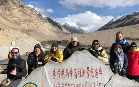
The road continues into the valley toward Rongbuk, where Everest becomes the main subject. Surrounding ridges restrict the wider panorama, while the north face has a much stronger presence.
The Tibet Everest Base Camp map distinguishes Rongbuk, visitor viewing areas and facilities. The tourist area commonly marketed as EBC should not be confused with expedition camps or permission to continue toward the glacier.
Keeping Gawula and Rongbuk in the plan gives you two complementary views. Nearby ridges can hide neighbouring summits once you enter the Rongbuk valley.
Peiku Tso: a western setting for Shishapangma
Shishapangma rises south of Peiku Tso. The regional government’s Nyalam account describes this lake-and-mountain relationship. Suitable positions around the lake and adjoining roads offer a different prospect from a tiny summit on the distant Gawula horizon.
A return trip from Everest to Shigatse does not automatically include Peiku Tso. A journey continuing toward Gyirong or farther west may make the area more relevant, with the road and stopping places agreed in advance.
Can Everest, Cho Oyu and Shishapangma fit one route?
Yes. A broad panorama may provide distant sightings without visiting three base camps. Closer attention to Shishapangma calls for considering the western road corridor.
| Viewing aim | Route pattern | What it adds | Main planning consequence |
|---|---|---|---|
| Everest with a group panorama | Shigatse, Tingri, Gawula and Rongbuk, then return | Wide view followed by Everest’s north-side view | Fits an Everest-focused journey; distant peaks remain weather dependent |
| Add a stronger Shishapangma prospect | Everest area, then a suitable western connection toward Peiku Tso | Lake-and-mountain views beyond the main Everest approach | Requires an onward route or extra return driving |
| Continue toward Kailash | Everest area, Saga and Darchen, with the exact road chosen separately | Combines Himalayan viewing with a different mountain range | A substantially longer regional journey, not a short summit detour |
The first choice is usually sufficient if your priority is Everest and a sense of the surrounding Himalayas. The Shigatse tourist map places these viewing opportunities alongside the wider regional route choices. CHIBET’s published eight-day Lhasa Everest Base Camp tour is one example of an Everest-focused journey; a Peiku Tso extension needs separate confirmation, and the schedule is not a medical recommendation.
If Shishapangma is a specific photographic goal, say so before booking. A Peiku Tso stop needs actual time in the schedule. Seeing its name beside the road on a map does not establish that a group departure will stop there.
Foreign-passport visitors need an organised Tibet trip with the required permits, as stated in current official travel guidance. Arrange extra road sections through the operating agency rather than planning an independent side trip.
Tibet mountain ranges map: where does Kailash fit?
Kailash belongs to the Gangdise, usually grouped within the Transhimalaya, north of the main Himalayan belt. Everest, Cho Oyu and Shishapangma belong to the Himalayas. A broad phrase such as “the Himalayan region” can include surrounding highlands without making their named ranges identical.
On an Everest Kailash map, the journey crosses between mountain systems. Nyainqentanglha is another separate system, north and northeast of Lhasa; the mountains around Namtso therefore belong to a different geographic setting from the Everest group.
Combining Everest and Kailash means continuing across western Tibet. A practical starting comparison is an Everest-area-to-Saga driving day, followed by another long stage toward Manasarovar and Darchen. That is two substantial transfer days before any Kailash walking, not a promise that every traveller should follow that pace. Extra lake time, rest or a different road connection adds days. The Mount Kailash map places Darchen and the circuit separately from the Himalayan viewpoints.
When are the peaks more likely to be visible?
Spring and autumn are commonly chosen for Himalayan viewing, while summer’s wetter conditions can interrupt summit views. Winter can bring very clear air, but also cold, wind and snow-related road disruption. Tibet’s official climate overview describes the broad dry season from October to April and wetter season from May to September; local mountain weather varies within those periods.
Cloud can gather around a summit while the road below stays sunny. A clear view of Everest also says little about conditions at Shishapangma farther west, so a sunrise stop cannot guarantee a visible summit.
An overnight in the Everest region can provide another viewing opportunity, but the overnight altitude and facilities must suit the travellers. It should not be added simply to chase a photograph.
Published access guidance last checked: 26 October 2026. Viewpoint locations and peak heights are separate from day-to-day operations. The operating agency should reconfirm the road, permitted visitor area, any vehicle transfer and accommodation for the actual travel dates. This map is not a live opening notice.
Conclusion
For an Everest-first trip, Gawula and the Rongbuk approach offer a useful combination of panorama and closer viewing. Add the western Shishapangma direction when it fits your onward journey or is a priority in its own right.
Tell CHIBET your dates, available days and the peaks you most hope to see through our contact us page. Ask for an Everest-focused route or a comparison including the western Shishapangma direction, with viewing stops and overnight bases identified. The licensed operating partner confirms access and the travel arrangements.
Frequently Asked Questions
FAQ
Can you see the Himalayas from Lhasa city?
Lhasa is surrounded by mountains, but the city is not a dependable viewpoint for the Everest group or the main Himalayan crest. Plan a separate southern or southwestern journey if those peaks are your goal. A skyline visible from a Lhasa hotel should not automatically be labelled Himalayan.
Do you need to trek to see Everest from Tibet?
An organised road-based visit can reach the designated north-side viewing area without a multi-day approach trek. Walking within the visitor area is different from entering expedition terrain. The exact vehicle arrangements and accessible limits depend on current operations.
Can a non-climber visit Cho Oyu or Shishapangma base camp?
Do not assume a climbing base camp is an ordinary sightseeing stop. Expedition access, permitted trekking and roadside viewing are different arrangements. A non-climber would need confirmation of the specific activity and access permission before including either base camp in a tour.
Are mountain-view stops guaranteed on a group tour?
A tour can list a scheduled viewpoint, but it cannot guarantee visible summits. Confirm that the named stop is included, particularly if photography is your main interest. Road restrictions or weather can also require the guide to change a planned stop.