A Tibet tourist map is less about pinpoints and more about combinations. Tibet’s top attractions — the Potala Palace, Yamdrok and Namtso lakes, Everest Base Camp, Mount Kailash, the Nyingchi forests — fall along four main travel routes connected through Lhasa. Connect them in the right order and an eight-day trip can cover the classic highlights without unnecessary backtracking. This page is one of 25 connected guides in our Tibet map hub, which links every Tibet map page on this site.
These are the core places to visit in Tibet, grouped by the four main routes: the Central Tibet loop, the northern lake route, the Everest and far-west route, and the eastern Nyingchi route. Lhasa is the cultural core that anchors all four. For each group you’ll find altitudes, distances from Lhasa, minimum days and the season limits that decide whether it fits your trip. If you haven’t yet read how the seven divisions fit together, start with our Tibet regions map guide, then come back here for the sights.
Quick Tibet Tourist Map Facts
The Top Tibet Attractions on One Map
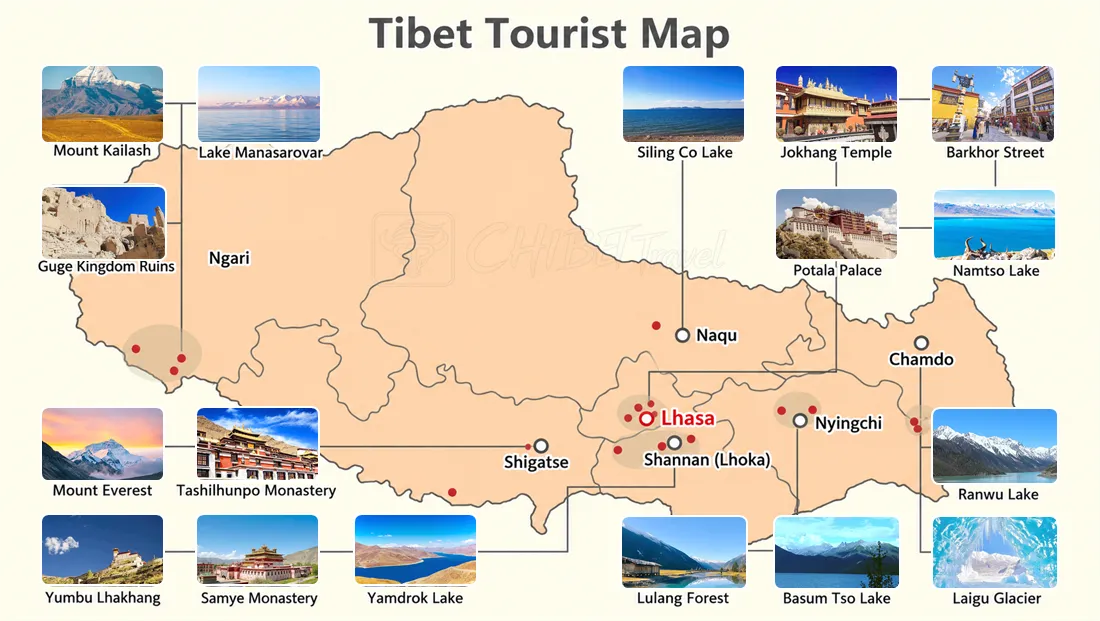
Short answer first: these 17 sights cover the main attractions and route choices for most first and second Tibet trips —
Potala Palace, Jokhang Temple and Barkhor Street in Lhasa;
Laigu Glacier and Ranwu Lake in Chamdo;
Lulang Forest and Basum Tso Lake in Nyingchi;
Yamdrok Lake, Samye Monastery, and Yungbulakang Palace in Shannan;
Everest Base Camp and Tashilhunpo Monastery in Shigatse;
Mount Kailash, Lake Manasarovar and Guge Kingdom in Ngari;
Namtso Lake and Siling Co Lake in Nagqu.
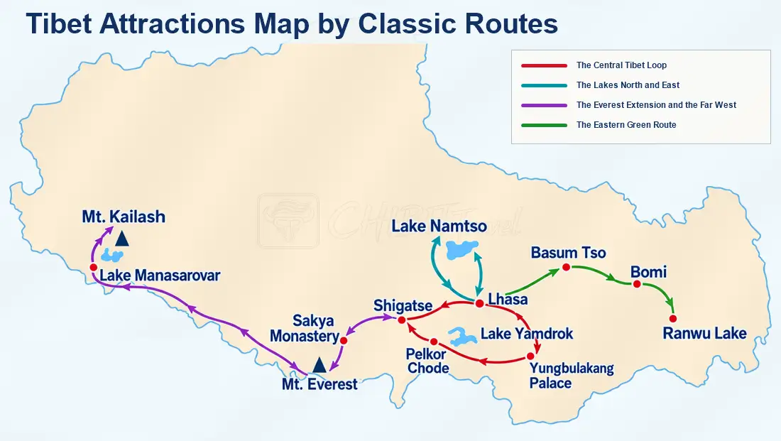
The map below shows where they sit; the table underneath gives each one’s region, altitude and the time it deserves.
| Attraction | Region | Altitude | Direction from Lhasa | Suggested time |
|---|---|---|---|---|
| Potala Palace | Lhasa | About 3,650 m | In the city | Half day |
| Jokhang Temple | Lhasa | About 3,650 m | In the city | 1–2 hours |
| Barkhor Street | Lhasa | About 3,650 m | Circles Jokhang Temple | 1–2 hours |
| Yamdrok Lake | Shannan | 4,441 m | About 110 km southwest | Day trip or en route west |
| Yungbulakang Palace | Shannan (Tsedang) | About 3,700 m | About 150 km southeast | Half day; pairs with Samye |
| Samye Monastery | Shannan | About 3,580 m | About 120 km southeast | Day trip from Lhasa or Tsedang |
| Tashilhunpo Monastery | Shigatse | About 3,840 m | About 245 km west | Half day |
| Everest Base Camp & Rongbuk Monastery | Shigatse (Tingri) | EBC area about 5,200 m; Rongbuk about 4,980 m | About 700 km southwest | 2 days from Shigatse; part of an 8-day Lhasa–Everest loop |
| Mount Kailash | Ngari (Purang) | Kora area about 4,600–5,630 m | About 1,200 km west | 3 days for the 52-km kora |
| Lake Manasarovar | Ngari (Purang) | Around 4,590 m | About 1,200 km west, near Kailash | En route to Kailash |
| Guge Kingdom Ruins | Ngari (Zanda) | About 3,680 m | About 1,400 km west, beyond Kailash | Half day; far-west loop only |
| Namtso Lake | Lhasa (Damxung) / Nagqu (Baingoin) | 4,718 m | About 240 km north | Long day trip or 1–2 days |
| Siling Co Lake | Nagqu (Baingoin / Xainza) | About 4,530 m | About 560 km northwest, beyond Namtso | 2 days; often combined with Namtso |
| Basum Tso Lake | Nyingchi (Gongbo’gyamda) | About 3,480 m | About 350 km east | Half day; en route east |
| Lulang Forest | Nyingchi (Bayi) | About 3,400 m | About 470 km east | Half day; en route east |
| Ranwu Lake | Chamdo (Basu) | About 3,850 m | About 750 km east | 2 days by road |
| Laigu Glacier | Chamdo (Basu), about 30 km beyond Ranwu | Village about 3,800 m; glacier area about 4,100 m | About 780 km east | Half day from Ranwu |
Tibet Attractions by the Numbers
Before the routes, the figures that decide whether a sight fits. Altitude sets how many nights you need around it, distance from Lhasa sets the driving days, and the permit status decides whether you can reach it at all. Read this table as the map’s legend: every pin on the tourist map sits somewhere in these ranges.
| Measure | Typical figure | What it means for your itinerary |
|---|---|---|
| Attractions listed on this map | 17 major sights | Enough to fill a first or second trip; not a list to complete in one visit |
| Lhasa’s own altitude | About 3,650 m | Your acclimatisation base — give it two nights before any high route |
| Highest overnight on the classic route | Rongbuk / EBC area, about 4,980–5,200 m | One night, and the reason the Everest leg is usually the last big push |
| Highest pass on the Lhasa–Everest road | Above 5,000 m (several in a row) | Passes come in clusters; a “short” day can still be a big-altitude day |
| Distance Lhasa to Everest Base Camp | About 700 km | Two long driving days each way; never a day-trip |
| Distance Lhasa to Namtso | About 240 km | Reachable as a long day trip, but better with an overnight |
| Distance Lhasa to Kailash | About 1,200 km | Separate western expedition; 13–15 days round trip |
| Distance Lhasa to Ranwu | About 750 km east | Eastern corridor; belongs to a longer eastern trip, not the classic loop |
| Minimum days for the classic route | 8 days | The single most common first-trip length; seven is possible but tight |
| Additional permit needed beyond the main permit | Everest, Kailash and some border areas | Decides whether a pin on the map is reachable on your permit |
Why Lhasa Always Comes First on the Map
Every route on the tourist map starts and ends in Lhasa, and that is not an accident of cartography. The city is the lowest major base you will use on a Tibet trip at about 3,650 m, it holds the densest cluster of cultural sights, and it is where the road and flight networks converge. Spending your first two nights here does two jobs at once: it lets you see the Potala Palace, Jokhang Temple and Barkhor before the long drives, and it lets your body adjust before you climb towards Yamdrok and the Everest passes. Skipping the Lhasa buffer and heading straight west is the single most common reason a first trip feels hard.
Reading Distance Against Altitude, Not Just Kilometres
On this map, a short line can be a hard day and a long line can be an easy one. Yamdrok Lake is only about 110 km from Lhasa but the road lifts you over a pass above 5,000 m to reach it. Namtso is about 240 km north, but the last stretch climbs to nearly 5,200 m at the lake itself. Everest is 700 km southwest across several high passes. Compare that with the eastern route, where Basum Tso sits about 350 km east but the road stays lower as it drops into forest. The lesson for planning is simple: measure each leg by how high it climbs, not by how far it runs.
Grouping Sights by Route, Not by Popularity
The 17 attractions fall into four route clusters, and almost every sensible itinerary is built from one cluster plus Lhasa. The Central loop gathers the Potala, Jokhang, Barkhor, Yamdrok, Gyantse and Shigatse into a compact four-day circuit. The northern lake route adds Namtso and, for longer trips, Siling Co. The Everest and far-west route chains Shigatse, Tingri, Everest Base Camp and — if you have the days and the permits — Kailash and Manasarovar. The eastern route gathers Basum Tso, Lulang, Ranwu and Laigu. Picking sights by cluster rather than by rank is what keeps an eight-day trip from turning into a tour of car windows. The Tibet regions map shows how these clusters line up with the seven divisions, and the Tibet travel route map tracks each one day by day.

Lhasa First: The Cultural Core That Anchors Every Route
Most itineraries on this map connect through Lhasa, making it the natural starting point for the main Tibet routes. The Potala Palace, Jokhang Temple and Barkhor pilgrim circuit form the cultural core, while Sera and Drepung fill a second Lhasa day on the classic eight-day itinerary. Treat the first days as acclimatization as much as sightseeing: the city sits at about 3,650 meters, and many of the routes on this map climb substantially higher — our Lhasa map covers the city’s old town, monasteries and transport in detail.
The Central Tibet Loop (Red Line): Yamdrok, Gyantse and Shigatse
Best for: first trips, culture plus big-lake scenery, three to four days.
From Lhasa, the southern route crosses Gampa La (about 5,030 m), drops toward the turquoise waters of Yamdrok Lake at 4,441 meters, passes Karola Glacier and Gyantse’s Kumbum, and continues to Shigatse and Tashilhunpo Monastery, the traditional seat of the Panchen Lama. The drive from Lhasa to Shigatse via Yamdrok and Gyantse covers roughly 360 kilometers of paved highway. Samye Monastery, Tibet’s first monastery, is a separate detour south in the Yarlung Valley.
The Northern Lake Route (Teal Line): Namtso
Namtso anchors the teal line at 4,718 meters, about 240 km north of Lhasa. The road crosses the 5,190-meter Nagen La before the lake and the Nyenchen Tanglha range appear together. It works as a long day trip, but it is a full day on the road and the lake sits nearly 1,100 meters above Lhasa, so many travelers overnight nearby to catch sunrise. Farther north, Siling Co — one of Tibet’s largest lakes, at about 4,530 meters — sits deep in the northern lake belt; it is usually planned as a longer northern-lakes extension, often combined with Namtso. For every major lake side by side, see our Tibet lakes map.
The Everest Extension and the Far West (Purple Line)
If Everest is the goal, the classic eight-day route gives you time for Lhasa, Yamdrok, Gyantse, Shigatse and the Everest region without adding another major route cluster.
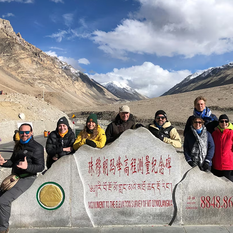
From Shigatse, the road heads southwest through Lhatse and Tingri, crossing Gyatso La at about 5,248 meters and then Gawu La at about 5,198 meters, the viewpoint pass that drops into the Everest valley. Everest Base Camp sits at around 5,200 meters, with Rongbuk Monastery at about 4,980 meters nearby. When the weather is clear, the northern face of Everest is clearly visible from the high passes and the base camp area; the Lhasa to Everest Base Camp map breaks down this leg day by day.
Most itineraries spend one night near Everest. Guests staying near the mountain may have a chance to see sunset and sunrise, but both depend on weather and cloud conditions. The return route in our current itinerary takes a different Himalayan road via Dinggye, the Dinggye Xilin Viewpoint and Sakya Ancient Town before returning to Shigatse. Tashilhunpo Monastery is then visited on the final drive from Shigatse back to Lhasa.
Beyond Everest, the same purple line keeps stretching west: about 600 more kilometers to Ngari, where Lake Manasarovar sits at around 4,590 meters, the 52-kilometer, three-day kora circles Mount Kailash — see our Mount Kailash map — and the Guge Kingdom murals wait at Tsaparang. This far-west run is a trip of its own — four to six extra days minimum, additional permits, and long driving days. It never fits a one-week plan, and pretending otherwise is the commonest route-planning mistake we see.
The Eastern Route (Green Line): Basum Tso, Nyingchi, Bomi and Ranwu
Scenery, not monuments, is the draw here: the route generally stays lower than the Everest and Kailash corridors, spring turns the Bomi valleys pink, and travelers often come east for the contrast.
East of Lhasa the map turns green, and the first stop is Basum Tso — a forest-ringed lake at about 3,480 meters, roughly 350 km out. Past the lake, the road reaches Nyingchi (Bayi), then continues toward Bomi, known for its spring peach blossoms, and on to Ranwu Lake and Midui Glacier. For travelers who prefer lower altitudes, this is the easiest corridor on the map.
Which Tibet Sights Fit into Eight Days?
Eight days is enough for a classic first Tibet trip, but the best combination depends on which route you want to follow. Two practical options are:
- Lhasa – Yamdrok – Gyantse – Shigatse – Everest Base Camp: the classic southern route, combining Lhasa’s main cultural sights with Yamdrok Lake, Gyantse, Shigatse and the Everest region.
- Lhasa – Yamdrok – Gyantse – Shigatse – Everest Base Camp – Namtso: a broader eight-day route that adds Namtso by keeping Lhasa sightseeing focused on the Potala Palace, Jokhang Temple and Barkhor Street.
Our 8 Days Lhasa–Everest Base Camp Tour follows the first pattern, while the Lhasa–Everest–Namtso Tour combines the Everest route with Namtso.
Other major areas need more time. Mount Kailash and western Ngari are a separate long-distance route, while Nyingchi, Bomi, Ranwu and Laigu belong to the eastern Tibet corridor. Trying to add these routes to the same eight-day trip usually makes the itinerary much tighter.
Simple rule: use eight days to build one coherent route rather than trying to collect every major attraction on the map; our Tibet travel route map compares every itinerary length from 4 to 15 days.

Minimum Days and Seasonal Limits, Attraction by Attraction
The map decides distances; the calendar decides access. These are the limits worth checking before you fix dates.
- Lhasa and the Central loop — year-round; winter is cold but clear and quiet
- Nyingchi peach blossoms — roughly mid-March to mid-April; the single biggest seasonal draw in eastern Tibet
- Namtso — the pass road typically closes or becomes unreliable after heavy snow; May to October is generally the easier travel window, subject to road conditions
- Everest Base Camp — April to June and September to October often offer clearer mountain views; July–August monsoon clouds often hide the summit
- Mount Kailash — May to September; the Saga Dawa Festival, usually in May or June, draws the biggest pilgrim crowds
Nature or Culture? Reading the Map by Interest
If your group splits by interest, the map also suggests some useful patterns. Culture-first travelers can focus on the Lhasa–Gyantse–Shigatse corridor and add Samye or Sakya; nature-first travelers can point east to Bomi and Ranwu, or north to Namtso. Everest combines dramatic scenery with major cultural stops, so it works well for travelers who want both.
| Traveler type | Best cluster on the map | Sights to prioritise | Days needed |
|---|---|---|---|
| First trip, culture first | Central loop | Potala Palace, Jokhang Temple, Barkhor, Tashilhunpo, Gyantse Kumbum | 4–5 days with Lhasa |
| First trip, scenery first | Everest route | Yamdrok Lake, Everest Base Camp, Rongbuk, high passes | 8 days from Lhasa |
| Short trip (5–6 days) | Lhasa plus one lake | Lhasa sights, Yamdrok day trip, optional Namtso | 5–6 days |
| Pilgrimage and far west | Ngari route | Mount Kailash, Lake Manasarovar, Guge Kingdom | 13–15 days |
| Low-altitude and forest | Eastern route | Basum Tso, Lulang Forest, Ranwu Lake, Laigu Glacier | 7–10 days |
| Repeat traveler | East or far west | Whichever cluster the first trip skipped | 10 days or more |

Important: All foreign passport holders need a Tibet Travel Permit, arranged through a licensed Tibetan tour operator, and guided travel throughout the region. Permit requirements for individual routes have been adjusted over time — for example, since June 2025 several regular-route destinations (including Everest Base Camp, the Gyirong route, Samye and the standard G318 line) no longer require the separate Aliens’ Travel Permit, while Kailash and other restricted western routes still do, plus a military-area clearance. Because these rules can change with policy, this page does not treat any single list as permanent. Your operator confirms the exact requirements for your itinerary at booking; our Tibet permit map lays out which routes typically need which documents, with the current status dated.
One final reading tip: the distances on this page are road distances, not straight lines. On the Qinghai-Tibet Plateau, a relatively short map distance can still mean a long driving day because of mountain roads, high passes and sightseeing stops — which is exactly why the clusters, not the pins, should shape your itinerary. For the boundary and division drawing behind these clusters, the authoritative reference is the official standard map service from China’s Ministry of Natural Resources.
Frequently Asked Questions
Tibet Tourist Map FAQ
Show the top Tibet attractions on one map
Tibet’s major attractions sit along four routes that all connect through Lhasa. The Central loop (Lhasa–Yamdrok–Gyantse–Shigatse) carries the Potala Palace, Jokhang Temple, Barkhor, Yamdrok Lake and Tashilhunpo; the northern lake route adds Namtso (4,718 m) and Siling Co; the Everest and far-west route continues to Everest Base Camp (about 5,200 m), Mount Kailash and Lake Manasarovar; and the eastern route covers Basum Tso, Lulang Forest, Ranwu Lake and Laigu Glacier. Map the clusters first, then pick the route. See the Tibet regions map for how the clusters match the seven divisions.
Which Tibet sights fit into a seven-day itinerary?
Seven days comfortably covers Lhasa plus one loop — most commonly the classic Lhasa–Yamdrok–Gyantse–Shigatse–Everest route, which is usually run as an eight-day trip and can be tightened to seven by trimming a Lhasa day. Namtso can be added only if you give up a Lhasa monastery day. Seven days does not fit Everest and Kailash; keep Kailash for a separate, longer western trip.
Group Tibet attractions by route and travel time
Three to four days: the Central loop (Lhasa, Yamdrok, Gyantse, Shigatse). One to two days: Namtso or a northern lake extension. Eight days: the classic Lhasa–Everest route, including Everest Base Camp and Rongbuk. Ten to twelve days: add Nyingchi, Bomi, Ranwu and Laigu in the east. Thirteen to fifteen days: add Ngari for Mount Kailash, Lake Manasarovar and Guge. Each cluster is a coherent route; mixing too many tightens every driving day. The Tibet travel route map lays these out day by day.
Can Yamdrok, Namtso and Everest Base Camp fit into the same week?
All three fit into eight days, not seven: the Namtso version of the classic route covers Yamdrok, Everest Base Camp and Namtso by trading the Drepung and Sera monastery day in Lhasa for the lake, since Namtso sits on the northern lake route rather than the main Lhasa–Everest road. If you only have seven days, keep the classic southern route and drop Namtso.
Besides the Potala Palace and Everest, which sights are worth adding?
The most common additions are Gyantse’s Kumbum stupa, Sakya Monastery, Samye Monastery in the Yarlung Valley, Namtso Lake, and the Bomi–Ranwu area in eastern Tibet. Spring visitors often make the Bomi peach-blossom valleys and Ranwu Lake their main destination, while repeat travelers head further west to Mount Kailash and the Guge Kingdom ruins.
Which sights need a special permit beyond the standard Tibet Travel Permit?
Everest Base Camp, the far-western Ngari routes towards Kailash and Manasarovar, and some border areas need an Alien’s Travel Permit (and for Ngari, a further military-area permit) arranged in advance. Lhasa, Shigatse city and the eastern Nyingchi corridor sit inside the standard permit. Check the Tibet permit map before you lock an itinerary, because a pin you can see on the tourist map may need paperwork you don’t yet hold.
How many days do the eastern Tibet sights actually take?
The eastern corridor is longer than it looks. Basum Tso and Lulang can be reached from Lhasa in a day each, but Ranwu and Laigu Glacier sit about 750 km east and realistically need two driving days each way, so a proper eastern trip runs seven to ten days on its own. Most travelers treat the east as the whole point of a second trip rather than a side trip from the classic loop. See the Tibet lakes map for how Basum Tso and Ranwu fit with the plateau’s other lakes.
Is the tourist map the same as the route map?
No. This page maps what to see and groups the attractions by region and route. The Tibet travel route map maps how to string them into day-by-day itineraries, with driving distances and overnight stops. Use this page to decide which sights you care about, then the route map to see whether the days actually fit.
Where do these figures come from?
Altitudes, road distances and driving times on this page were reviewed in October 2026 and are planning figures for a private vehicle with a driver, not published survey values; mountain-road speeds of 40 to 60 km/h are the basis for the time estimates. Permit rules quoted here reflect the regular-route adjustment that took effect in June 2025 and are given as a dated snapshot only — requirements are confirmed per itinerary by a licensed operator. Boundary and division drawing follows China’s official standard maps published by the Ministry of Natural Resources.