A Tibet city map answers a question that generic maps blur: which places are actual destinations, and which are just overnight bases between them? Tibet has seven prefecture-level divisions — six cities plus Ngari Prefecture — but many of the towns you actually sleep in are smaller route bases such as Tingri, Saga and Darchen. This guide maps both layers, with Chinese, Tibetan, pinyin names and altitudes for each, and explains the role every town plays on a real itinerary. It is one of 25 connected guides in our Tibet map hub, which links every Tibet map page on this site.
Quick Tibet City Map Facts
The Seven Major Cities and Regions of Tibet on a Map
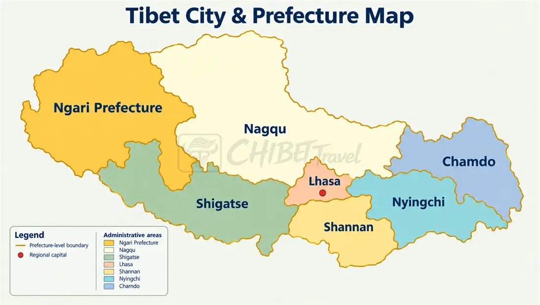
Short answer first: Tibet’s seven prefecture-level divisions are Lhasa (拉萨), Shigatse (日喀则), Shannan or Lhoka (山南), Nyingchi (林芝), Chamdo (昌都), Nagqu (那曲) — six cities — plus Ngari Prefecture (阿里), whose seat is Shiquanhe (狮泉河). For most travelers, Lhasa and Shigatse are the two that feel like full-size cities — for the capital in depth, see our a detailed Lhasa city map; the rest are compact regional centers whose value is location, not size. The English spellings below are the forms travelers commonly encounter; Chinese maps, tickets and road signs may use different romanization systems. To check a place name or a boundary against the authoritative version, use the official standard map service run by China’s Ministry of Natural Resources.
| City | Chinese | Tibetan | Pinyin | Seat altitude | Travel role |
|---|---|---|---|---|---|
| Lhasa | 拉萨 | ལྷ་ས། | Lāsà | About 3,650 m | Capital, cultural core and the arrival hub for most first-time itineraries |
| Shigatse | 日喀则 | གཞིས་ཀ་རྩེ། | Rìkāzé | About 3,840 m | Major regional service hub for Everest and western Tibet |
| Shannan (Lhoka) | 山南 | ལྷོ་ཁ། | Shānnán | Zedang, about 3,560 m | Easy day trips from Lhasa: Samye, Yungbulakang Palace, the Yarlung Valley |
| Nyingchi | 林芝 | ཉིང་ཁྲི། | Línzhī | Bayi, 2,995 m | Lower-altitude scenic base for eastern Tibet routes |
| Chamdo | 昌都 | ཆབ་མདོ། | Chāngdū | About 3,250 m | Eastern gateway for Sichuan–Tibet overland routes and a regional service center |
| Nagqu | 那曲 | ནག་ཆུ། | Nàqǔ | About 4,500 m | Rail and G109 stop between Lhasa and Qinghai; mainly a transit point |
| Ngari | 阿里 | མངའ་རིས། | Ālǐ | Shiquanhe, about 4,280 m | Far-west regional center and main service hub for Kailash and Guge routes |
How to Read the Tibet City Map
This map separates Tibet’s main cities from the smaller towns travelers use along the road. Every place falls into one of three practical roles:
- Major cities — the seven prefecture-level seats and their main urban services.
- Travel bases — smaller towns where driving days often end.
- Attractions — destinations worth visiting in their own right, mapped separately in our Tibet tourist map.
This page focuses on the places travelers use, not administrative borders. For county lines and the seven prefecture-level divisions, see our the seven prefecture-level divisions.

Two rules make the city map useful before you look at any single town. First, every base is measured by sleeping altitude, because the night height, not the day’s drive, decides how you feel the next morning. Second, every base is either a destination — worth its own time — or a gateway that mainly breaks a long drive. Once you can tell those two apart, an itinerary built from this map almost writes itself: days in the destinations, nights in the gateways, and the altitude climbing in stages rather than in one jump. The tables below put the numbers behind both rules, starting with the seven regional seats and then the gateway towns that sit between them.
Where Are Tibet’s Major Cities?
On a map the pattern is easy to remember: Lhasa sits in the center-south, with Shigatse west, Shannan south, Nyingchi south-east, Chamdo east, Nagqu north and Ngari far to the west. What the map hides is the scale — from Lhasa it is about 1 hour to Zedang in Shannan, about 4 to 5 hours to Shigatse (280 km), about 3–4 hours north to Nagqu (about 320 km), and about 4 to 5 hours by road to Nyingchi (about 400 km).
Travel Bases Beyond the Seven Regional Seats
Most itineraries do not run Lhasa to Everest Base Camp in one day. The distance is about 620 km by the northern road (expressway as far as Shigatse), or about 700 km if you take the southern road past Yamdrok Lake and Gyantse, with several high-altitude passes along the way. That stretch is where the overnights happen — keep an eye on road distances between these bases: the standard pattern is a night in Shigatse, followed by an overnight in the Everest area — or in Tingri at about 4,300 m if you prefer a lower-altitude hotel.
| Town | Chinese | Tibetan | Pinyin | Altitude | Why you stop here |
|---|---|---|---|---|---|
| Gyantse | 江孜 | རྒྱལ་རྩེ། | Jiāngzī | About 4,020 m | Pelkor Chode, Kumbum Stupa and the Gyantse fortress make it a genuine sight, not just a stop. It lies on the traditional southern route between Lhasa and Shigatse; the expressway bypasses it. |
| Tingri (Dingri) | 定日 | དིང་རི། | Dìngrì | About 4,300 m | Lower-altitude alternative to sleeping near Rongbuk before the Everest area; useful for a shorter high-altitude overnight |
| Saga | 萨嘎 | ས་དགའ། | Sàgā | About 4,500 m | Common overnight stop on the road between the Everest area and Mount Kailash |
| Gyirong Town | 吉隆镇 | སྐྱིད་གྲོང་གྲོང་རྡལ། | Jílóng Zhèn | About 2,800 m | Valley town near the Nepal border; a lower-altitude overnight on Kathmandu overland routes. The Gyirong Port route is currently suspended; see the route table below. |
| Darchen | 塔尔钦 | དར་ཆེན། | Tǎ’ěrqīn | About 4,575 m | Base town at the foot of Mount Kailash; the Mount Kailash kora (pilgrimage circuit) starts and ends here |
| Bomi | 波密 | སྤོ་མེས། | Bōmì | About 2,730 m | Scenic road-trip base on the eastern G318 between Nyingchi and Ranwu Lake; a useful stop for the region’s forests and glaciers |

Which Tibet Travel Base Fits Your Route?
| Route | Typical base sequence | What the bases do |
|---|---|---|
| Lhasa cultural trip | Lhasa | Main stay for the whole trip |
| Lhasa–Shigatse–Everest | Lhasa → Shigatse → Everest region | Lhasa provides acclimatization and cultural sightseeing; Shigatse is the main overnight and service hub before Everest; the Everest region or Dingri provides the high-altitude overnight. |
| Kathmandu–Tibet overland | Gyirong → Saga → Shigatse | Normal overland sequence when the crossing is operating. The Gyirong route is currently suspended following the August 26, 2026 disaster; reopening has not been announced. |
| Mount Kailash | Shigatse → Saga → Darchen, or fly toward Burang → Darchen | High-altitude transit nights plus the kora base |
| Lhasa–Nyingchi scenic | Lhasa → Nyingchi (Bayi) → Bomi | Lower-altitude scenic route with forest and glacier stops |
| Sichuan–Tibet overland | Chamdo → Lhasa | Eastern transit legs on the long drive in |
Tibet’s Travel Bases by the Numbers
Altitude, not distance, is what decides where you sleep on a Tibet route. The table below reads the map by overnight height: the lower a base sits, the more comfortable the night, and the higher it climbs, the more it costs you in sleep and recovery. Use it to sanity-check any itinerary against the towns it actually uses.
| Travel base | Approximate altitude | Role on the map | Overnight feel |
|---|---|---|---|
| Lhasa | About 3,650 m | Gateway and cultural core | The lowest major base; two nights here are the standard acclimatisation buffer |
| Shigatse | About 3,840 m | Western service hub | Comfortable, full services, the last big town before the high west |
| Gyantse | About 4,020 m | Historic stop on the central loop | Small but well-serviced; a common first night out of Lhasa |
| Nyingchi (Bayi) | 2,995 m | Eastern low-altitude base | The easiest night on the map; forest air and warmer temperatures |
| Bomi | About 2,730 m | Eastern transit base | Very low for Tibet; a good recovery stop on the eastern route |
| Tingri | About 4,300 m | Everest staging town | The lower alternative to an Everest overnight |
| Everest Base Camp area / Rongbuk | About 4,980–5,200 m | High-altitude highlight | The highest common overnight; one night only for most travelers |
| Saga | About 4,500 m | Far-west transit node | A hard night — functional rather than comfortable |
| Darchen | About 4,575 m | Kailash kora base | The start and end of the kora; basic but the only option |
| Gyirong Town | About 2,800 m | Nepal border base | The lowest stop on the Nepal-bound route; crossing status is separate |
How to Use the Base Sequence
Read the route table above from left to right and you have the skeleton of a trip: each arrow is a driving day, and each named town is a night. The habit worth building is to check the altitude of every arrow’s end point before you accept the sequence, because a route that looks short on the map can still finish at a base high enough to spoil the next day. If two consecutive nights both sit above 4,500 m, that is the sign to insert a lower staging stop rather than push straight through.
The Two Exceptions Worth Knowing
Two bases break the usual pattern. Gyirong Town sits far lower than the rest of the Nepal-bound route at about 2,800 m, which makes it a comfortable night but also a stop whose crossing status is checked separately from the altitude. Darchen sits high at about 4,575 m but has no lower alternative, because the Kailash kora starts and ends there — so it is a night you accept rather than choose. Everywhere else on the map, a lower base is usually within reach.
Why Altitude, Not Distance, Chooses Your Overnight Stops
Two towns an hour apart on the map can mean very different nights. Tingri at about 4,300 m and the Everest Base Camp area at about 4,980–5,200 m sit on the same road, but they are separated by hundreds of metres of sleeping altitude — the difference between a difficult night and a very difficult one. This is why experienced itineraries climb in stages: Lhasa first, then Shigatse, then Tingri, then the high camp, so that each night is only a modest step above the last. Sleeping altitude is the number to check on the city map, and it is why the lowest towns such as Nyingchi and Bomi are prized as recovery stops even though they are far from the headline sights.
Gateway Towns Versus Destinations
The map mixes two kinds of place, and confusing them wastes days. Destinations — Lhasa, Gyantse, Shigatse, Nyingchi — are worth their own time, with sights, monasteries and markets. Gateways — Tingri, Saga, Darchen, Gyirong Town — exist mainly to break a long drive or to stage the next day, and hold little you would travel for on their own. A good itinerary spends its days in the destinations and its nights in the gateways, rather than treating every stop as a sight. The Tibet tourist map shows which places are attractions, and this city map shows which are just where you sleep.
Reading the City Map Against the Route Map
The city map answers “where are the towns,” but not “do the nights fit.” For that, run it alongside the Tibet travel route map, which lays out each day’s drive, and the Tibet distance map, which gives the gaps between the bases. If a route lists a town you cannot find a comfortable altitude for, that is the signal to reorder the nights rather than push through.
Airports, Railway Stations and Road Nodes
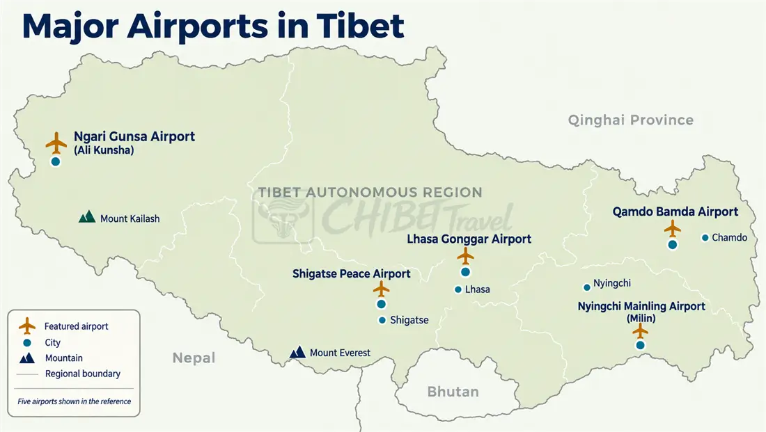
Eight passenger airports serve the region: Lhasa Gonggar (贡嘎机场, the region’s international passenger gateway, about 70 km from central Lhasa), Nyingchi Mainling (林芝米林), Shigatse Peace (日喀则和平), Shigatse Dingri (日喀则定日), Ngari Burang (阿里普兰), Ngari Gunsa (阿里昆莎), Shannan Longzi (山南隆子) and Qamdo Bamda (昌都邦达).
Dingri is a newer gateway to the Everest area, with limited scheduled flights. Airport schedules change by season (Last checked: October 4, 2026); check current flights before planning around a specific airport, and treat the IATA codes below as identifiers only — route availability is the thing to confirm. Longzi has limited scheduled service and is not normally used on standard first-time Tibet itineraries. Burang is the airport to know for Kailash-bound travelers: it is much closer to Mount Kailash and Lake Manasarovar than Gunsa, with scheduled Lhasa flights. See more at Tibet Airport Map.
| Airport | IATA | Elevation | Serves | Best for |
|---|---|---|---|---|
| Lhasa Gonggar | LXA | 3,570 m | Lhasa / Shannan | Most first-time arrivals |
| Nyingchi Mainling | LZY | 2,949 m | Nyingchi | Scenic eastern Tibet routes |
| Shigatse Peace | RKZ | 3,801 m | Shigatse | Shigatse and western Tibet routes |
| Shigatse Dingri | DDR | 4,316 m | Dingri / Everest area | Everest-area access |
| Ngari Burang | APJ | 4,255 m | Burang / Kailash area | Mount Kailash and Lake Manasarovar routes |
| Ngari Gunsa | NGQ | 4,274 m | Ngari / Shiquanhe | Western Ngari and Guge routes |
| Shannan Longzi | LGZ | 3,950 m | Longzi County | Limited regional connections |
| Qamdo Bamda | BPX | 4,333 m | Chamdo | Eastern Tibet and Sichuan connections |
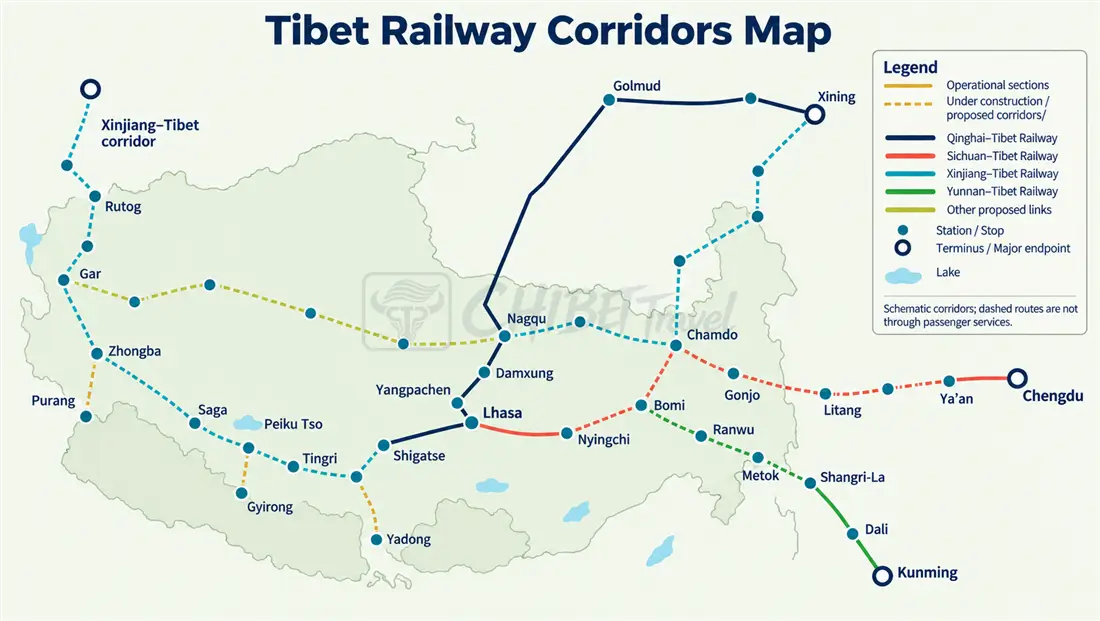
Three rail lines run in Tibet. The Qinghai–Tibet Railway is the main long-distance rail route into Tibet: Xining to Lhasa takes around 20 to 22 hours, with the line continuing through Nagqu. From Lhasa, the Lhasa–Shigatse railway runs west, while the Lhasa–Shannan–Nyingchi railway runs east. Together, the three operating lines form a Y-shaped network serving five of Tibet’s seven prefecture-level divisions. Tickets are sold through China Railway’s official 12306 system and other authorized channels; check the current timetable and ticket requirements before departure. For a wider read of the region’s rail network, see our Tibet train map.
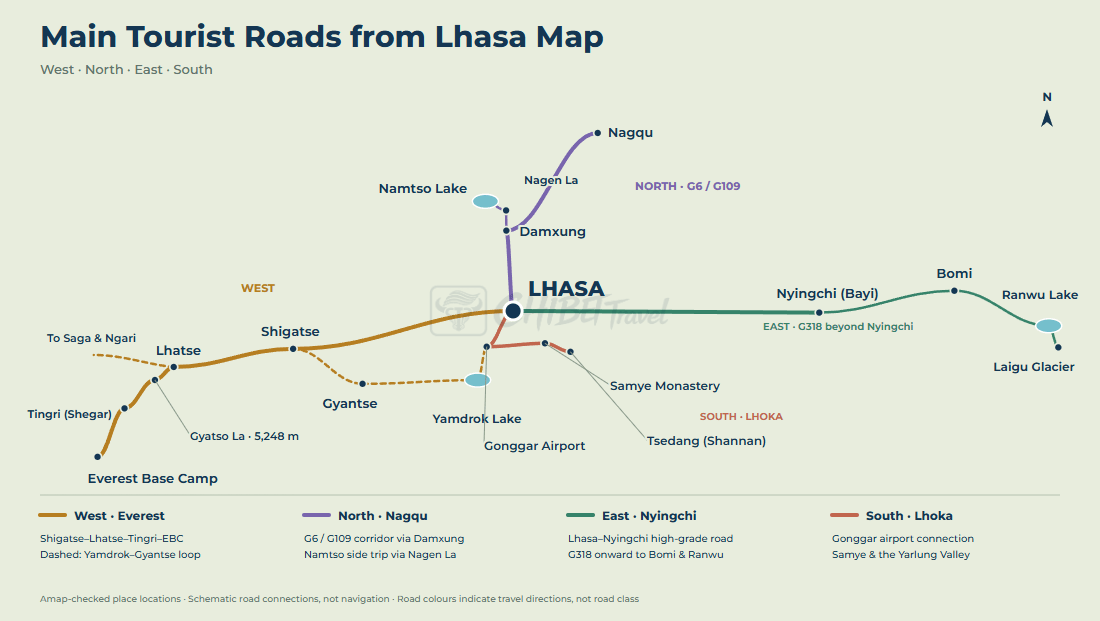
On the road, Lhasa is the main hub for the routes most travelers use. High-grade roads connect the capital with Shigatse to the west, Nyingchi to the east, Nagqu to the north and Zedang in Shannan to the south-east. For western itineraries, the key junctions come after Shigatse: one route continues south toward Tingri and Everest, while another heads west through Saga toward Ngari and Mount Kailash.
Important: All foreign passport holders need a Tibet Travel Permit arranged through a licensed Tibetan tour operator. Additional permits may apply on some routes, especially in Ngari. Requirements can change — see our Tibet permit map for the current route-by-route breakdown.
Frequently Asked Questions
Tibet City Map FAQ
Show Tibet cities and travel bases on a map
Tibet has seven prefecture-level divisions — Lhasa, Shigatse, Shannan (Lhoka), Nyingchi, Chamdo, Nagqu and Ngari — and each has a seat that doubles as a travel base. Lhasa anchors every route; Shigatse is the western hub; Nyingchi (Bayi) is the eastern low-altitude base; and Nagqu, Chamdo and Ngari town (Shiquanhe) serve the northern, eastern and far-western edges. Beyond the seats, the map adds the gateway towns — Gyantse, Tingri, Saga, Darchen and Gyirong Town — that break the long drives.
Where should travelers stay between Lhasa and Everest?
The standard sequence is Lhasa, then Shigatse (about 3,840 m) as the main overnight and service hub, then Tingri (about 4,300 m) as the lower staging option before the Everest region. Most itineraries sleep one night in or near the Everest Base Camp area at about 4,980–5,200 m and then descend. The point of the sequence is to climb in stages rather than jump straight from Lhasa to the highest night.
Which Tibet towns are gateways rather than attractions?
Tingri, Saga, Darchen and Gyirong Town are primarily gateways: they exist to break a drive or stage the next day rather than to be visited for their own sake. Lhasa, Gyantse, Shigatse and Nyingchi are the opposite — destinations with sights, monasteries and markets worth real time. Reading the map this way keeps an itinerary from treating every overnight stop as a place to tour.
Which of Shigatse, Tingri, Saga and Darchen are sights, and which are just overnight stops?
Shigatse is the one true destination of the four, with Tashilhunpo Monastery and full services. Tingri, Saga and Darchen are almost entirely gateways. Tingri stages the Everest region at a lower altitude; Saga is a hard, functional transit night on the far-west road; Darchen is the start and end point of the Kailash kora. Plan to spend time in Shigatse and just sleep in the other three.
Why do towns that look close on the map still need an overnight stop?
Because the road does not run as the crow flies. On the map a gap may look like an hour, but the real road climbs passes above 5,000 m, drops into valleys and doubles back, so a short line can be a full driving day. The Tibet distance map gives the true road gaps rather than the straight-line ones, which is why Tingri, Saga and Darchen exist as overnight stops at all.
Which base is best if I want to avoid high overnight altitudes?
Nyingchi (about 3,000 m) and Bomi (about 2,700 m) in the east are the lowest bases on the map, and Gyirong Town (about 2,800 m) is the lowest Nepal-bound stop. If altitude is your main concern, the eastern corridor is the gentlest route, because the road drops into forest rather than climbing onto the plateau. The classic Everest route, by contrast, inevitably includes at least one night near or above 5,000 m.
What services can I expect in the smaller bases?
The bigger seats — Lhasa, Shigatse, Nyingchi — have hospitals, banks, a wide choice of hotels and reliable electricity. The gateway towns — Tingri, Saga, Darchen and Gyirong Town — are far more basic: simple guesthouses, limited hot water and few dining options. Treat the gateways as functional nights rather than comfortable ones, and carry what you need, especially cash, because card and mobile payment can be unreliable far from the seats.
How do the city map and the route map work together?
The city map answers where the towns are and how high each one sits; the Tibet travel route map answers whether the nights fit given the driving days. Use the city map to check the altitude of each overnight, and the route map to check that the daily distances leave time to reach that altitude before dark. The Tibet altitude map fills in the rest of the elevation picture.
Where do these figures come from?
The seven prefecture-level divisions, their seats and the total area of 1.2028 million km² come from the Xizang Autonomous Region government’s regional profile; population figures are from the 2020 national census as announced by the regional government. Boundary and place-name drawing follows China’s official standard maps published by the Ministry of Natural Resources. Seat altitudes, airport elevations and road distances are planning figures compiled in October 2026 and are rounded; airport schedules, rail timetables and the Gyirong crossing status were last checked on October 4, 2026 and can change.