Darchen is the preparation and recovery base for the three-day Mount Kailash kora, about a week’s overland travel from Lhasa via Shigatse, Saga and Manasarovar. You sleep here before the trek, store luggage, meet the trail transfer and return after Zutulpuk.
Quick Darchen Map Facts
Darchen Location Map: Where It Sits on the Lhasa to Kailash Journey
Most tours begin with pickup in Lhasa and two city days before moving west. A common sequence is Lhasa → Shigatse → Everest/Tingri → Saga → Manasarovar → Darchen.
| Tour stage | Guided route | Typical overnight | Typical drive time | Road distance (typical) |
|---|---|---|---|---|
| Days 1–3 | Lhasa arrival and sightseeing | Lhasa | — | — |
| Day 4 | Lhasa via Yamdrok to Shigatse | Shigatse | 5-6 h | 270 km |
| Day 5 | Shigatse to Everest/Tingri area | EBC or approved lower hotel | 5-6 h | 240 km |
| Day 6 | Everest/Tingri to Saga | Saga | 6-7 h | 300 km |
| Day 7 | Saga via Manasarovar/Rakshastal to Darchen | Darchen | 8-9 h | 490 km |
| Days 8–10 | Kailash kora | Dirapuk, Zutulpuk, then Darchen or onward | 3 walking days | 52 km (kora) |
The exact day numbering changes by departure, but the logic does not: Darchen follows several overland stages. It is not a separate town break that can be inserted at short notice.

Important: International visitors travel in Tibet through a qualified agency with the required permit, guide and tourist vehicle. Passport and China visa scans should be provided well ahead of departure. Requirements and route access were last checked on 15 October 2026.
Darchen Hotel & Restaurant Map: Sleep, Eat and Meet Your Guide
This map covers the hotels and eating places used around Darchen’s main street, where you can prepare for the Mount Kailash kora, meet your guide and arrange luggage storage before departure.
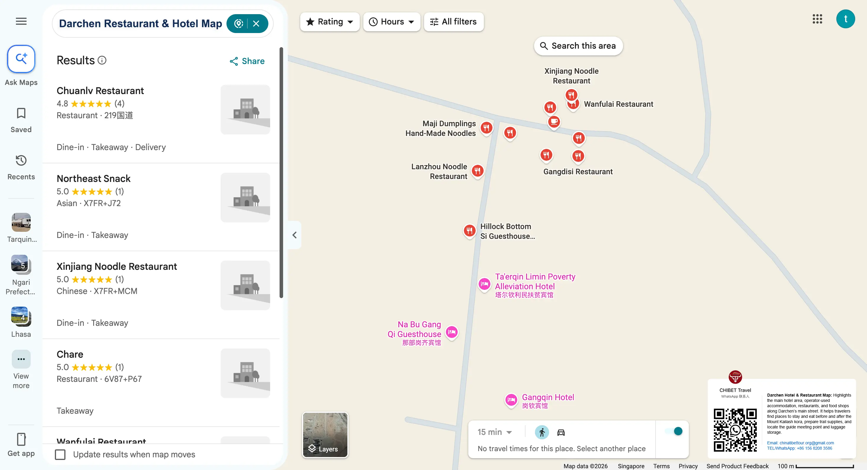
Accommodation is simple, so check heating, private bathroom facilities and the distance to your morning departure point rather than relying on hotel names alone. The map marks the contracted hotel area, guide meeting point and luggage storage. Your operator coordinates accommodation changes and related arrangements.
For meals, local restaurants serve Tibetan and Sichuan dishes, including noodles, momos and rice. Buy water and trail snacks the evening before the kora, and confirm whether meals are included in your itinerary. Share dietary requirements before leaving Lhasa.
The eco-bus departure point is near the edge of town. Your guide will direct you there on the first morning. At around 4,575 m, keep arrival evening simple: confirm the transfer, prepare your walking bag and rest early.
Darchen Attractions Map: Three Guided Kora Days
The Darchen attractions map should use different lines for eco-bus transfer and walking.
Day 1: Darchen to Dirapuk
The group normally takes an approved local transfer toward the trail start, then walks through the Tarboche area to Dirapuk. A current group example uses about 6 km of vehicle transfer and 13 km of trekking, with a night at Dirapuk around 5,210 m.
Day 2: Dirapuk over Dolma La to Zutulpuk
The hardest day covers about 22 km and crosses Dolma La at roughly 5,630 m. The descent continues well beyond the pass before the group reaches Zutulpuk guesthouse.
Day 3: Zutulpuk to the Pickup Point
The final section may be about 6.5–10 km depending on the current pickup arrangement. The group then returns by approved transfer to Darchen or continues on the contracted road stage.
| Kora day | Main section | Group implication |
|---|---|---|
| 1 | Transfer, Tarboche, Dirapuk | First trail overnight near 5,000 m |
| 2 | Dirapuk, Dolma La, Zutulpuk | Highest and longest walking day |
| 3 | Zutulpuk, pickup, Darchen | Walking plus organized transfer |

Darchen Altitude Map: The Hardest Day Is Not the Longest Day
Darchen is already far higher than Lhasa. The next two nights rise again before Dolma La. The Darchen altitude map should therefore start in Lhasa and include Shigatse and Saga, showing how the group reaches western Tibet over several days.
This itinerary sequence is not proof that every traveler is acclimatized. Anyone with worsening symptoms must tell the guide. The route, medical decision and group timing may need to change.

Darchen Travel Route Map: Decide the Exit Before You Start Walking
On standard Kailash tours, the group normally returns toward Saga and Lhasa. On an extended Guge departure, it may continue from the final kora morning toward Zanda.
Make that choice before permits and bookings. The two exits require different vehicles, hotels and road plans.
| Booked tour type | After the kora | Next main overnight |
|---|---|---|
| Standard Kailash group | Return east via Saga | Saga |
| Kailash and Guge group | Continue west under the same approved itinerary | Zanda |
| Non-walking approved tour | Darchen/Manasarovar visits with guide and vehicle | As contracted |


Choose the Darchen Trip Style That Fits Your Pace
A join-in group shares a fixed departure, guide and tourist vehicle with other travelers. It normally offers the clearest price and the most stable Darchen operation, but walking pace, hotels and road stops follow the published itinerary.
A private tour may adjust rest time, hotel category and the Manasarovar sequence before permits are processed. It still uses an arranged guide, vehicle and route, and the kora’s basic terrain cannot be customized away.
Travelers who may skip the kora should agree on the fallback in advance. The operator needs to know whether the guest remains in Darchen, visits an approved road-access point or changes the next overnight.
What the Darchen Tourist Map Should Not Suggest
It should not present Manasarovar, Purang or Guge as spontaneous local side trips. Nor should it imply that a porter, trail bed or vehicle can always be arranged on arrival. Confirm these before the group leaves Lhasa.
Trail status, eco-bus arrangements, guesthouse availability and porter allocation are dynamic. Mark them “Last checked: 15 October 2026” and reconfirm shortly before departure.
Conclusion
Related maps: Tibet Map hub, Darchen Map, Ngari Map, Mount Kailash Map, Manasarovar Lake Map, Tibet Trekking Map, Tibet Travel Route Map, Tibet Altitude Map, Tibet Permit Map.
Book or compare this route: Kailash kora group departures
Darchen is the preparation and recovery base for the Kailash kora. Read its hotels, meals, transfers and trail nights as one continuous journey that began in Lhasa.
CHIBET can explain standard and Guge-extended departures. The licensed Tibet operating partner handles the contract, permits, guide, legal transport, accommodation and trail operation.
Frequently Asked Questions
Darchen Map FAQs
Can I travel from Lhasa to Darchen independently?
No. International visitors need a qualified agency to arrange the permit, guide, vehicle and itinerary.
Can I walk the Kailash kora without the group guide?
Do not plan on separating from the organized operation. Walking arrangements, checkpoints, transfers and overnights are coordinated by the operator and guide.
Can I stay in Darchen while the group walks?
An approved non-walking arrangement may be possible, but it must be agreed with the operator and reflected in the itinerary before travel.
Can I change from the standard tour to Guge in Darchen?
No last-minute change should be assumed. Guge requires a different route, vehicle plan, hotels and approvals; select that departure before permit processing.