Tibet is not one flat plateau. The land is a stack of high uplands, mountain ranges, river valleys and lake basins, and the way those pieces sit together determines where a road can run, where towns grew, and how long a drive really takes. This map breaks that terrain into the five regions a traveler crosses. It sits inside our wider Tibet map hub, which links every map page on the site.
Quick Facts
Sources: Elevation shares come from the Xizang Autonomous Region government’s regional profile, which states that 85.1 percent of the region lies above 4,000 m and 45.6 percent above 5,000 m. Valley and farmland shares are given in qualitative terms because official sources state the pattern — flat land is a small fraction of the total, and farmland concentrates on it — without publishing one figure comparable across sources. Figures checked October 2026.
Tibet’s High Plateau: The Landform That Shapes Everything
Plateau is not another word for flat. The Tibetan Plateau is high ground with mountains, valleys and basins built into it, and that internal relief is the ground a traveler actually drives across.
Terrain here means the shape of that ground rather than a height reading. Elevation is one number for one place, topography is the form of the land, and terrain is the way ranges, valleys and basins assemble into the regions described below. That is why this page explains where roads and towns ended up instead of listing heights.
The Tibetan Plateau Is Not Flat
Official figures from the Tibet Autonomous Region government put the region at an average elevation above 4,000 m, with 85.1 percent of its land lying above 4,000 m and about 45.6 percent above 5,000 m. An average is not a description of any single place. Lhasa sits near 3,650 m, and inside the same region the ground falls into forested valleys and climbs onto passes above 5,000 m.
Those same official figures make the other point: valley plains and river flatlands account for only a small share of the land, yet they carry the great majority of the region’s cultivated farmland. That single fact explains a good deal about Tibet. Flat ground is scarce, so the fields and the towns crowd onto the small share of it.
Terrain decides where a road can go. On ground this broken, a line drawn between two towns is only a wish until a valley or a pass makes it real, and the drive that follows is usually longer and slower than the shape of the map suggests.
Why Southeast Tibet Looks So Different
Head southeast from Lhasa and the landscape changes faster than the altitude figures alone would explain. Official ecological surveys describe a gradient from warm and humid in the southeast to cold and arid in the northwest, with vegetation running from forest, through shrub and meadow, to steppe and finally desert.
The Nyingchi valleys sit at the humid end of that gradient. Many of them lie lower than Lhasa, and moist air from the southeast works its way in along the valleys. Low valley floors, steep sides and steady rain together explain why the southeast is forested and the northwest is bare, and why two ends of the same region can feel like separate journeys.
Tibet’s Major Terrain Regions: Mountains, Valleys and High Plateaus
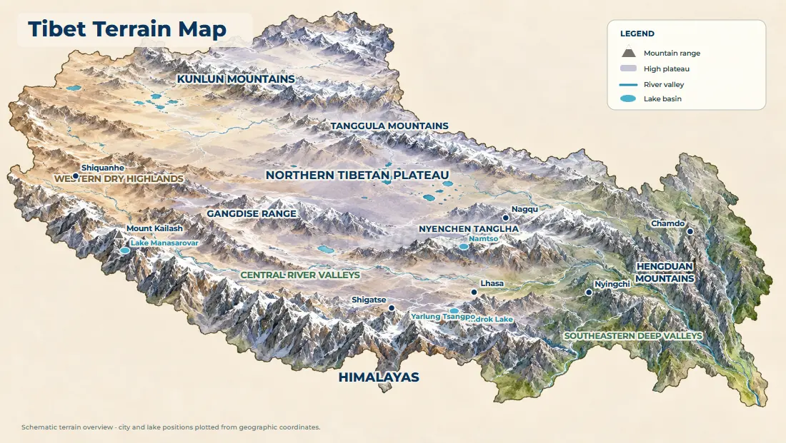
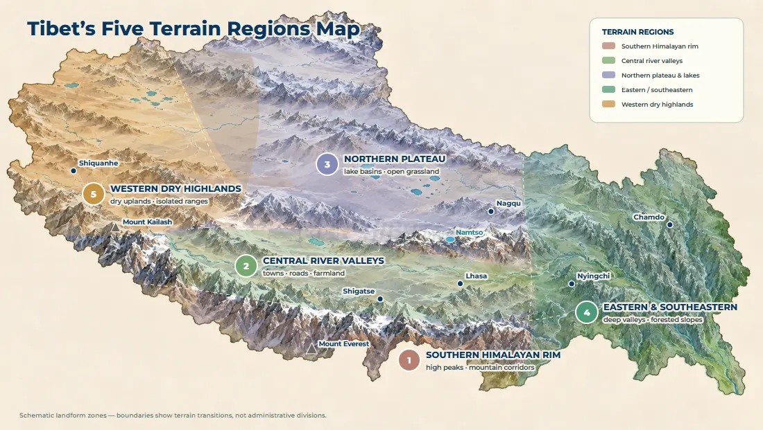
Five regions cover the ground a visitor crosses, and each one is a different combination of the same four pieces: uplands, ranges, valleys and basins. The Tibet regions map handles the administrative side; this section reads the land itself, from the southern rim to the western highlands.
Southern Tibet: Himalayas and High Mountain Corridors
The Himalaya forms the southern wall of the region and does two jobs at once. It holds the highest peaks, and it blocks much of the monsoon moisture before it reaches the plateau behind. Along the southern rim, travel terrain is therefore a set of corridors between that wall and the uplands: open ground alternates with passes and short narrow sections, which is why southern routes keep climbing and dropping even on a map that looks straightforward. The peaks along it are catalogued on the Tibet mountains map.
Central Tibet: River Valleys and Plateau Uplands
Central Tibet is where the rivers do the organizing. The Yarlung Tsangpo runs across the south between the Himalaya and the Gangdise range, and the Lhasa River joins it at Qushui, which has made the Lhasa valley one of the region’s main settlement corridors for centuries. Shigatse sits in the same belt of broad valleys, with plateau uplands between the river floors and the mountains beyond. Road distance here is largely a question of whether a route stays down in a valley or climbs out of it, and the Tibet river map follows those valleys in more detail.
Northern Tibet: High Plateau, Mountain Ranges and Lake Basins
North of Lhasa, the Nyenchen Tanglha separates the Lhasa valley system from the Nagqu grasslands and pockets the Namtso basin behind it. Beyond that the land opens into the Changtang — “northern wilderness” in Tibetan — a plateau that official sources describe as broadly 4,500–5,000 m, with a long belt of lakes running through its southern half. Low rainfall, thin grass and very wide horizons are what follow from that, and driving here is about distance rather than gradient. The plateau’s northern edge is framed by ranges including the Kunlun and Tanggula. The Qinghai–Tibet railway crosses the Tanggula Pass at about 5,072 m, the highest railway point on Earth.
Eastern and Southeastern Tibet: Deep Valleys and Forested Mountains
Eastern Tibet is ridge-and-gorge terrain. The Hengduan system runs as parallel ranges with deep valleys between them, and the rivers that drain the plateau cut through those ranges in long, steep courses. The Parlung Tsangbo joins the Yarlung Tsangpo in the Great Bend, where the river turns south and the land drops sharply from plateau to valley floor. This is the part of Tibet where a short horizontal distance on the map separates a pass from a forest floor, and where the glaciers feeding those valleys sit within sight of the road. The Tibet glacier map picks up that thread.
Western Tibet: Dry Highlands and Isolated Mountain Landscapes
Western Tibet is the driest and most open end of the plateau. Ngari sits farther from the monsoon moisture, higher and much drier, and its ground cover is high-altitude grassland, barren ground and desert-like basins. The Gangdise range runs across the region as an isolated line of mountains rather than a continuous wall, with Mount Kailash and Lake Manasarovar as the two features most travelers know by name. Travel here combines two things that sound contradictory: high mountains and extremely open plateau at the same time.
| Terrain region | Main landforms | Elevation character | How it shapes travel |
|---|---|---|---|
| Southern rim | Himalayan mountain wall, corridor valleys, high passes | High passes commonly exceed 5,000 m | Carries some of the region’s most-used travel roads |
| Central valleys | Broad river valleys, terraces, surrounding uplands | Main valley floors near 3,600 m | Where the towns, main roads and most overnight stops are |
| Northern plateau | Open plateau, lake basins, outlying ranges | Broadly 4,500–5,000 m | High, exposed driving with very long sightlines |
| Eastern and southeastern | Deep parallel valleys, gorges, forested slopes | Steep fall from plateau to valley floors | Greener valleys and some lower-altitude travel corridors |
| Western highlands | Dry uplands, isolated ranges, lake basins | High and generally dry | Long westbound routes repeatedly climb and descend between valleys |
Regions here follow landforms rather than administrative boundaries, so they describe the ground a route crosses rather than where one prefecture ends and the next begins.
Tibet Terrain by the Numbers
Before the regions, the whole plateau in figures. These are the numbers that explain why the map looks the way it does and why a route that looks short can take a full day; every figure is a long-term average rather than a reading for a particular place.
| Measure | Typical figure | What it means for a traveler |
|---|---|---|
| Average elevation, Tibet Autonomous Region | Above 4,000 m | The baseline altitude almost every route works from |
| Land above 4,000 m | 85.1 percent | Very little of the region sits at the altitudes a sea-level visitor is used to |
| Land above 5,000 m | About 45.6 percent | Nearly half the region is higher than any pass most visitors cross |
| Valley plains and river flatlands | A small share of the land | Flat ground is scarce, so towns and farmland crowd onto it |
| Farmland on that flat ground | The great majority of the cultivated total | Why the settlement pattern follows the rivers, not the map centre |
| Typical low valley floor (Lhasa area) | About 3,600–3,650 m | Where most trips start and acclimatize |
| Common high passes on travel routes | 5,000–5,300 m | Where a driving day spends its hardest hours |
| Changtang plateau band | Broadly 4,500–5,000 m | Open, high, sparse driving in the north |
| Highest railway point (Tanggula Pass) | About 5,072 m | The upper limit of what rail crosses on the plateau |
| Elevation spread within the region | From below 3,000 m to above 8,000 m | One region, many terrains — altitude alone describes none of them |
The two elevation shares in this table — 85.1 percent above 4,000 m and 45.6 percent above 5,000 m — are the figures published by the Tibet Autonomous Region government in its regional profile. The valley and farmland rows state the pattern rather than a percentage, because official sources describe the concentration of farmland on flat ground without publishing a single comparable number. Treat all of them as long-term averages: terrain here is a description of a whole region, not a forecast for any one day of driving.
How Tibet’s Terrain Shapes Travel Routes
Terrain stops being background scenery the moment a route is fixed. A drive on a Tibet itinerary is a sequence of valley sections and mountain crossings, and those two together decide how far a day can reasonably go.
Why Road Distance Can Be Much Longer Than It Looks on a Map
Road distance is not straight-line distance. A road has to find a valley to follow or a pass to cross, and in terrain this steep the detours are the rule rather than the exception. A straight line drawn between two towns crosses whatever happens to lie in the way, and what lies in the way is usually a mountain range. The Tibet distance map gives the road figures destination by destination, and the Tibet road map shows which highways carry them.
Why Roads Follow Valleys and Cross Mountain Passes
Valleys are the practical corridors across ground this high. They offer gentler grades, water, and the towns that grew where the two met, which is why the main routes out of Lhasa follow river lines for long stretches before turning to cross a range. A pass is where that logic changes: the road leaves the valley, climbs to the lowest gap it can find, and drops into the next drainage. Classic Tibet routes look indirect on a map because that is what the land allows.
A city’s altitude is a poor guide to the route that reaches it. A day that begins on a valley floor near 3,600 m can cross a pass above 5,000 m and finish lower than it started, and the pass count, not the town, sets the pace. The Gyatso La on the approach to Everest is the clearest case on the main travel routes, at about 5,250 m the high point of the drive, and it is not a place where anyone stays.
Lhasa–Shigatse–Everest: Valley to Himalayan High Ground
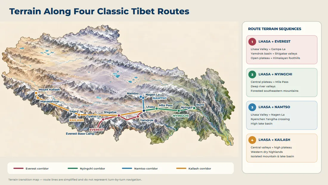
Terrain sequence: Lhasa Valley → Gampa La → Yamdrok basin → Gyantse–Shigatse valleys → open plateau → Himalayan foothills.
The southern route climbs out of the Lhasa valley over the Gampa La to the Yamdrok basin, drops through the Gyantse and Shigatse valleys, then runs west across plateau ground before the road turns south toward the Everest side. One journey can therefore hold a lake, a river valley, open uplands and a Himalayan approach inside a few days of driving, and the landscape changes more than the mileage suggests. The 8-day Lhasa Everest Base Camp tour follows this corridor.
Lhasa–Nyingchi: Plateau to Deep Forested Valleys
Terrain sequence: central plateau → Mila Pass → deep river valleys → forested southeastern mountains.
This is one of the sharpest terrain transitions in Tibet. The road east crosses the Mila Pass and then descends into the Nyingchi valleys, where the ground falls away into forest and the moisture that the plateau blocks farther south begins to arrive. Nothing in the first hour of the drive prepares a traveler for the last one.
Lhasa–Namtso: Valley to High Lake Basin
Terrain sequence: Lhasa Valley → Nagen La → northern lake basin.
The road north leaves the Lhasa valley, crosses the Nyenchen Tanglha at the Nagen La, and settles into the basin that holds Namtso. The pass and the basin are the whole story of this route: the climb is what makes the day feel long, and the enclosed ground is what holds the lake, a basin walled in by higher land on most sides.
Lhasa–Kailash: Central Plateau to Western Highlands
Terrain sequence: central Tibet → broad high plateau → western highlands → isolated mountain and lake landscapes.
The western route leaves the central valleys by way of Shigatse and then simply keeps going, across plateau ground that stays high and grows drier by the day. No single pass defines it; the distance is what makes the route. Kailash and Manasarovar are the features that anchor the far end, a mountain line and a lake basin in ground that is otherwise wide open. The 13-day Lhasa EBC Kailash Manasarovar tour runs the overland version of that westbound crossing.
What Each Route’s Terrain Actually Costs You in Time
The map above shows where the ground changes. The table below turns that into planning terms: how many passes a route crosses, roughly how much of a driving day the terrain consumes, and the one terrain feature most likely to slow you down.
| Route | Main terrain crossed | Notable passes | Terrain cost in time | The feature that slows you most |
|---|---|---|---|---|
| Lhasa–Shigatse (northern road) | Valley floor to rolling upland | Few high crossings | Low — mostly valley and expressway | Long valley stretches rather than gradient |
| Lhasa–Yamdrok–Gyantse–Shigatse | High pass, lake basin, river valleys | Gampa La, Karola area | Medium — several passes, slower grades | Repeated climbs out of each valley |
| Shigatse–Everest | Open plateau to Himalayan foothills | Gyatso La, Gawu La | High — two substantial passes | High-altitude pass crossings and slow sections |
| Lhasa–Nyingchi | Plateau to deep forested gorges | Mila Pass | Medium–high — long descent into gorges | Steep valley descent and winding gorge road |
| Lhasa–Namtso | Valley to enclosed lake basin | Nagen La | Medium — one big pass then basin | The single high pass on the way out |
| Shigatse–Saga–Darchen (Kailash) | Broad high plateau, dry west | Several moderate crossings | High — dominated by sheer distance | Distance, not any one pass |
Read this against the Tibet road map for the highway numbers, and against the Tibet altitude map for the heights behind each pass. The two together are why two routes with the same mileage rarely take the same time.
Reading Tibet’s Terrain for Trip Planning
Terrain is not scenery to admire from a window; it is the constraint that decides what an itinerary can physically do. Three habits make a plan more realistic before any booking is made.
Match the Region to the Season You Can Travel
The terrain regions do not share one travel calendar. The southern rim and the western highlands are exposed and cold out of season; the central valleys stay broadly workable all year; the southeastern gorges are greenest in summer but also wettest then. Choosing a terrain region first, then a month, is more reliable than the other way round — a pattern worked through month by month on our Tibet seasonal travel map.
Budget Driving Days by Pass Count, Not by Kilometres
On this ground, the number of passes is a better predictor of a hard day than the number of kilometres. A 300 km stretch that crosses two passes above 5,000 m is a longer, slower day than a 400 km run down a single valley. When an itinerary is tight, count the crossings first and trim the route that collects the most of them.
Use Valleys as Recovery, Not Just Scenery
Valley floors are the low points of a route and the places where altitude is easiest to recover from. A plan that alternates a high pass with a valley night is kinder to the body than one that climbs steadily without descending. The central valleys around Lhasa and Shigatse sit low enough to serve that role, which is one reason most itineraries anchor there. The elevation side of the same question is covered on the Tibet altitude map.

Frequently Asked Questions
Tibet Terrain Map FAQ
Is Tibet really a flat plateau?
Plateau describes elevation, not flatness. The Tibetan Plateau is high ground with mountain ranges, river valleys, lake basins and open uplands built into it. Official figures put 85.1 percent of the region above 4,000 m, and valley plains account for only a small share of the land, so a journey can move from broad valley floors to steep mountain terrain within a single day.
Why is Nyingchi so much greener than western Tibet?
Moisture and elevation working together. Nyingchi sits in the southeast, where humid air arrives and the valleys lie lower than Lhasa, so forest can grow on the slopes. Western Tibet is farther from that moisture, higher and much drier, and its ground cover is grassland, barren ground and desert-like basins. The southeast is not simply lower ground; it is lower ground that also gets the rain.
Why does Tibet have so many high-altitude lakes?
The terrain collects water. A high plateau full of enclosed basins, with ranges around them and no route to the sea, holds meltwater and rain where it falls. That is why the northern plateau carries a long belt of lakes, and why the same open ground that makes driving easy also makes the land wet in patches. The Tibet lakes map covers the lakes themselves.
Does Tibet’s terrain affect travel time?
Strongly. Roads follow valleys and cross passes instead of running straight, so road distance between two points sits well above straight-line distance, and the ground in between decides how much of a day the drive takes. Two routes with similar mileage can take very different times if one crosses four passes and the other crosses one. The Tibet altitude map handles the elevation side of that.
What is the highest pass on the main Tibet travel routes?
On the standard routes, the crossings on the Shigatse–Everest corridor are among the highest, with the Gyatso La at roughly 5,250 m and the Gawu La close behind at about 5,200 m. The Gampa La on the Lhasa–Yamdrok road is around 5,030 m, and the Nagen La on the way to Namtso is about 5,190 m. None of them is a place to linger; they are crossings, not destinations.
Why do two towns that look close on the map take so long to connect?
Because the straight line between them usually runs into a mountain range. A road has to descend into a valley, follow it, and climb to the lowest available gap before it can reach the next town, and each of those moves adds distance and time. The terrain, not the map scale, sets the real travel time.
Can I see glaciers and high mountains without a long western trip?
Yes. The southeastern valleys reached from Lhasa via the Mila Pass bring forest, glaciers and steep mountain ground within a manageable drive, because the terrain drops sharply from plateau to valley floor over a short horizontal distance. The far-west highlands hold the largest and most isolated mountain landscapes, but they need a dedicated long route. The Tibet glacier map lays out where the accessible glacier country sits.
Does the terrain make some routes unsuitable for a first trip?
It makes some routes long rather than impossible. The central valleys and the Lhasa–Everest corridor are the most forgiving, because the driving days are shorter and the altitude changes come in stages. The western highlands and the deep southeastern gorges are physically harder days with fewer places to stop, so they usually belong to repeat trips or to travelers with more time. See the Tibet travel route map for how the routes compare by length.
Which terrain regions can I cross in one trip?
Most first trips cross two or three. The Lhasa valley, the southern rim towards Everest and the lake basins north of Lhasa sit within reach of a single itinerary, because the roads run through the central valleys and only touch the edges of the high plateau. To see the whole spread — the forested southeastern gorges, the open Changtang and the far western highlands — you either need a much longer trip or a second visit. The Tibet mountains map shows where the main ranges and peaks cluster, and the Tibet road map shows the corridors that stitch the regions together.